place

Moor Park Golf Club

1923 establishments in EnglandGolf clubs and courses designed by Harry ColtGolf clubs and courses in Hertfordshire

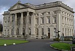
Moor Park Golf Club is located in Hertfordshire, England, and is considered by many to be the finest golf club in the county. It has two eighteen hole course; the High Course and the West Course of which the High Course is the more demanding having hosted its fair share of both professional tournaments and English Golf Union events, including the Carris Trophy every year from 1935 to 1987 and every fourth year subsequently. The West Course is an amalgam of holes from the original West and East Courses, forming two loops of nine holes to the west and north of the clubhouse. The clubhouse is set within Moor Park Mansion. The High Course Course type: Parkland Architect(s): Harry S. Colt. Holes: 18 Par: 72 Length: 6903 yards The club was featured in Sir John Betjeman's BBC TV documentary Metro-land (1973). Moor Park Golf Club was founded in 1923 and is currently preparing to celebrate its centenary in 2023. The club currently has approximately 1500 members, of whom 1000 are golfers, the remainder being composed of tennis members and social members. The club is run by a Board of Directors, all of whom are unpaid club members. The current Chairman of the Board is Ian Starr. The club also employs a Chief Executive, currently Amy Yeates, who reports to the Board. A senior member of the club acts as its President for a three year term. The present holder of the office is John Grossman.

Excerpt from the Wikipedia article Moor Park Golf Club (License: CC BY-SA 3.0, Authors).

Moor Park Golf Club
London Road, Three Rivers Batchworth

Geographical coordinates (GPS) Address Phone number Website Nearby Places
placeShow on map

Wikipedia: Moor Park Golf ClubContinue reading on Wikipedia

Geographical coordinates (GPS)

Latitude Longitude
N 51.628 ° E -0.449 °
placeShow on map

Address

Moor Park Golf Club

London Road
WD3 1QN Three Rivers, Batchworth
England, United Kingdom
mapOpen on Google Maps

Phone number

call+441923774113;+441923721650;+441923773146
Website
moorparkgc.co.uk

linkVisit website

Share experience

Nearby Places

Batchworth
Batchworth

Batchworth was once a hamlet and is now a civil parish and part of Rickmansworth in Hertfordshire. The parish of Batchworth was created on 1 April 2017 consisting of two Three Rivers District Council wards: Rickmansworth Town, and Moor Park and Eastbury. The first election to Batchworth Parish Council was on 4 May 2017. There are eight councillors; four in each ward.The Grand Union Canal passes through Batchworth. The Batchworth Canal Centre is alongside the Grand Union lock, near the junction of the A404 and A4145 roads. This is the home of the Rickmansworth Waterways Trust who run a visitors centre, a working heritage boat, a small outdoor cafe and co-ordination of the annual Rickmansworth Canal Festival.The future of the historic cotton mill is uncertain following its need of urgent repairs.Batchworth Sea Scouts have their headquarters alongside the canal. The Batchworth Dragons dragon boat club were born out of the scout group and competes at a national and international level.Batchworth Lake, created by the extraction of gravel for the original Wembley Stadium, is used for water skiing and forms part of Rickmansworth Aquadrome. Batchworth Heath is four hectares (ten acres) of designated common land around the junction of Batchworth Heath Hill, Batchworth Lane and White Hill, owned and managed by Three Rivers District Council. The habitat is heathland with an ancient pond and rich wildlife. Since July 2015 the site has been listed by Natural England as a Local Nature Reserve, but according to Three Rivers Council this is an error and they have asked Natural England to remove it from the list.

Rickmansworth (Church Street) railway station

Rickmansworth (Church Street) railway station was a London and North Western Railway (LNWR) station in Rickmansworth, Hertfordshire, UK. Opened in 1862, it was the terminus of a 4.5-mile (7.2 km) branch line which used to run from Watford. The station closed to passengers in 1952, although the line continued to be used as a goods line until 1967. Church Street station has since been demolished. Rickmansworth station is about 0.5 miles (0.80 km) northwest of the site of Church Street station. Opening on 1 September 1887, it continues to serve both the London Underground Metropolitan line and Chiltern Railways between Marylebone and Aylesbury via Harrow-on-the-Hill. Church Street station was the terminus of the Watford and Rickmansworth Railway (W&RR), a business venture of the Whig politician, Robert Grosvenor, 1st Baron Ebury (1801–1893). It opened on 1 October 1862. The line ran from Watford Junction to Rickmansworth with many small freight branches, the most notable of which ran to Croxley Green. Lord Ebury's plan was to extend the line south and to open a new railway to Uxbridge Vine Street on the Great Western Railway's Uxbridge branch. However, the GWR withdrew its funding for the scheme and line was never extended. The line failed to operate at a profit, the W&RR ran into financial difficulties, and eventually the operation was taken over by the London and North Western Railway in 1881. In 1923, under the London, Midland and Scottish Railway (LMS), the Rickmansworth line and the service from Watford Junction to London Euston was converted to fourth-rail electric trains. The station was renamed Rickmansworth (Church Street) on 25 September 1950. It continued to be operated as a branch line from Watford by British Rail until the passenger service was withdrawn on 3 March 1952. The station and tracks continued to be used for goods services until the line was cut back to one of the intermediate freight sidings. The track to Watford has since been removed; the trackbed to Watford is now the Ebury Way rail trail. The platforms and station buildings have been demolished; the site is now occupied by social housing. A new hotel now stands between the old station site and the canal.