Mont Noir
Belgium geography stubsLandforms of Nord (French department)Mountains of Hauts-de-FranceNord (French department) geography stubs
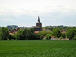
Mont Noir (Zwarte Berg in Dutch) is a 152 metres (499 ft) high hill located on the French-Belgian border, a few kilometres from Bailleul. It takes its name from the presence of a high concentration of black pine woodland, which covers the hillside.
Excerpt from the Wikipedia article Mont Noir (License: CC BY-SA 3.0, Authors).Mont Noir
Rue de Méteren - Route du Parc, Dunkirk
Geographical coordinates (GPS) Address Nearby Places Show on map
Geographical coordinates (GPS)
| Latitude | Longitude |
|---|---|
| N 50.7792 ° | E 2.7336 ° |
Address
Rue de Méteren - Route du Parc 1017
59299 Dunkirk
Hauts-de-France, France
Open on Google Maps


