place

Dyker Beach Park and Golf Course
1895 establishments in New York CityDyker Heights, BrooklynGolf clubs and courses in New York (state)Parks in BrooklynProtected areas established in 1895
Sports venues in Brooklyn
Dyker Beach Golf Course

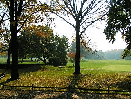
The Dyker Beach Park and Golf Course is a public park and a municipal, 18-hole, championship golf course in the southernmost part of Dyker Heights, Brooklyn, in New York City, United States. The area stretches from the Belt Parkway in the south to 86th Street in the north, between 7th Avenue on the west and 14th Avenue on the east. The course totals 217 acres and includes 6,548 yards of golf. Both the park's and the course's roots go back more than 100 years, and it is one of the most played public golf courses in the nation.The golf course is managed by the American Golf Corporation, which not only won the contract to run the majority of New York City courses in 1999 but also renovated and expanded the club house in 2007-2008. Dyker Beach Golf Course is one of the oldest golf courses in the United States and second oldest in New York City, behind Van Cortlandt Park, in the Bronx. The course is open all year round so long as weather conditions allow for play.

Excerpt from the Wikipedia article Dyker Beach Park and Golf Course (License: CC BY-SA 3.0, Authors, Images).

Dyker Beach Park and Golf Course
VA Hospital Entrance Road, New York Brooklyn

Geographical coordinates (GPS) Address Phone number Website External links Nearby Places
placeShow on map

Wikipedia: Dyker Beach Park and Golf CourseContinue reading on Wikipedia

Geographical coordinates (GPS)

Latitude Longitude
N 40.610833333333 ° E -74.019166666667 °
placeShow on map

Address

Dyker Beach Golf Course

VA Hospital Entrance Road
11228 New York, Brooklyn
New York, United States
mapOpen on Google Maps

Phone number

call+17188369722

Website
dykerbeachgc.com

linkVisit website

linkWikiData (Q5318678)
linkOpenStreetMap (199103470)

Dyker Beach Golf Course
Share experience

Nearby Places

Harbor Defense Museum

The Harbor Defense Museum, sometimes called The Caponier, located within the grounds of Fort Hamilton in the Bay Ridge section of Brooklyn is a 19th-century fort, New York City's only military museum and one of only seventy military museums in the United States that is funded and operated by the Defense Department.Caponiers, the technical name of the structure that now houses the museum, are outworks; in the case of Fort Hamilton its mission was to protect the main fortress from rear attacks. Originally a small fort within the larger fort, it now serves as the guardian of Fort Hamilton's history. Robert E. Lee served at Fort Hamilton in the 1840s, when there was only one Army. Because it was used as a warehouse after it was no longer needed for military purposes, it was better preserved than other parts of the fort. While the museum and fort were in danger of closing in the mid-1990s due to budget cuts, it was preserved due to an agreement between the fort and the United States Army Center of Military History and preservation efforts of the Fort Hamilton Historic Society. The museum continues to serve an educational role in explaining the history of the evolution of New York Harbor.Fort Hamilton is the "second-oldest continuously garrisoned federal post in the nation", second only to West Point and its ties to the community are part of the charm of the museum and the fort. Although The Caponier was always prepared for battle, with a 24-pound cannon aimed at New York Harbor, the fort never experienced a battle. The museum houses an array of artifacts from New York's military history including American Revolutionary War relics, uniforms from various wars, old maps of the fort, the post's old switchboard, an exhibit on a secret tunnel that connected Fort Hamilton with another base a half-mile away, a Confederate mine and a piece of the net that protected New York Harbor from German U-boats in World War I. It is also the temporary home of a Bay Ridge time capsule that was unearthed prematurely due to construction.

John Paul Jones Park

John Paul Jones Park is a public park located in Fort Hamilton, Bay Ridge, Brooklyn. The park borders Shore Road, Fourth Avenue, 101st Street, and Fort Hamilton Parkway. The park is managed by the New York City Department of Parks and Recreation, which acquired the property from the city of Brooklyn in 1897.John Paul Jones Park is named after the American patriot and naval commander of the same name, who was known for his leadership in the American Revolution. He is often referred to as "the father of the Navy." John Paul Jones Park is home to several memorials from various events in American history: Rodman gun: a massive, black, twenty-inch bore that was created in 1864 by artilleryman Thomas Jackson Rodman. It was originally situated in Fort Pitt, Pennsylvania, but was presented to the park by the United States Military in 1900. Today it dominates the park along with cannon balls that surrounds the landscape and is part of the Civil War Memorial. Revolutionary War Memorial: contains a bronze tablet that is inscribed into a granite boulder. This plaque was granted by the Long Island Society of the Daughters of the American Revolution in 1916 to commemorate the first resistance made to British arms in New York in August 1776. Dover Patrol Naval War Memorial: features a monument that was gifted by Sir Ashton Webb in 1931, from England after World War I. It serves as a dedication to the Dover Patrol for its service and comradeship in the American Naval Force in Europe during the first World War. The monument has a pyramid-shaped copper capstone at the top of the obelisk. In addition to these memorials is a 70 foot tall flag pole that once belonged to a Navy destroyer. It was added to the park in 1980 alongside a plaque that reads "in honor of John Paul Jones, the father of the Navy."

Dyker Heights, Brooklyn

Dyker Heights is a predominantly residential neighborhood in the southwest corner of the borough of Brooklyn in New York City. It is on a hill between Bay Ridge, Bensonhurst, Borough Park, and Gravesend Bay. The neighborhood is bounded by 7th and 14th Avenues, 65th Street, and the Belt Parkway on the west, east, north, and south, respectively. Dyker Heights originated as a speculative luxury housing development in October 1895 when Walter Loveridge Johnson developed a portion of woodland into a suburban community. It maintained its status as a wealthy neighborhood through the 20th century. During the height of his development, the boundaries were primarily between Tenth and Thirteenth Avenues and from 79th Street to 86th Street. The finest homes of the development were situated along the top of the 110-foot (34 m) hill, at about Eleventh Avenue and 82nd Street. Dyker Heights has a suburban character with detached and semi-detached one-and two-family homes, many of which have driveways and private yards, which are uncommon in parts of New York City. The neighborhood contains tree-lined streets, and there are very few apartment buildings. Dyker Heights can be divided in roughly three sections. The southernmost section, south of 86th Street and east of 7th Avenue, contains Dyker Beach Park and Golf Course. The central section between Bay Ridge Parkway and 86th Street, and between 14th Avenue and Fort Hamilton Parkway, is more exclusive in character. The northern border of the neighborhood is more closely integrated with surrounding areas. The Dyker Heights Civic Association, founded in 1928, is a civic group that represents the community's interests. The area as a whole is known for its Christmas lighting displays, which are often elaborate.Dyker Heights is part of Brooklyn Community District 10, and its primary ZIP Code is 11228. It is patrolled by the 68th Precinct of the New York City Police Department. Politically it is represented by the New York City Council's 43rd District.