Saint Bernard, Louisiana
Louisiana geography stubsPages with Spanish IPAUnincorporated communities in LouisianaUnincorporated communities in St. Bernard Parish, LouisianaUnincorporated communities in the New Orleans metropolitan area ... and 1 more
Use mdy dates from July 2023
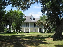
Saint Bernard (Spanish: San Bernardo [sam beɾˈnaɾðo]) is an unincorporated community in St. Bernard Parish, Louisiana, United States. The community is located on Louisiana State Highway 300, east of the Mississippi River and 8 miles (13 km) southeast of Chalmette. Saint Bernard is home to four sites on the National Register of Historic Places: the Dr. Louis A. Ducros House, the Kenilworth Plantation House, Magnolia Mound, and the Sebastopol Plantation House.
Excerpt from the Wikipedia article Saint Bernard, Louisiana (License: CC BY-SA 3.0, Authors).Saint Bernard, Louisiana
Bayou Road,
Geographical coordinates (GPS) Address Phone number Website Nearby Places Show on map
 Continue reading on Wikipedia
 Geographical coordinates (GPS)
| Latitude | Longitude |
|---|---|
| N 29.867222222222 ° | E -89.858611111111 ° |
Address
Los Isleños Museum Complex
Bayou Road 1357
70085
Louisiana, United States
Open on Google Maps