Beverly Hills, New South Wales

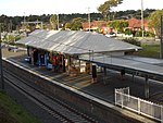
Beverly Hills is a southern suburb of Sydney, in the state of New South Wales, Australia. Beverly Hills is located 15 kilometres southwest of the Sydney central business district and is part of the St George area and is split between the local government areas of the Georges River Council and the City of Canterbury-Bankstown. The postcode is 2209, which it shares with neighbouring Narwee. Beverly Hills is mostly residential, consisting of many freestanding red brick and tile bungalows built in the years immediately after World War II. Many of these feature late Art Deco design elements. Medium density flats have been built in the areas close to King Georges Road and Stoney Creek Road.
Excerpt from the Wikipedia article Beverly Hills, New South Wales (License: CC BY-SA 3.0, Authors, Images).Beverly Hills, New South Wales
Melvin Street, Sydney Beverly Hills
Geographical coordinates (GPS) Address Nearby Places Show on map
Geographical coordinates (GPS)
| Latitude | Longitude |
|---|---|
| N -33.951388888889 ° | E 151.07944444444 ° |
Address
Melvin Street
Melvin Street
2209 Sydney, Beverly Hills
New South Wales, Australia
Open on Google Maps


