Dubris
Former populated places in KentGrade I listed buildings in KentGrade I listed lighthousesHistory of Dover, KentRoman fortifications in England ... and 5 more
Roman harbors in EnglandRoman sites in KentRoman towns and cities in EnglandSaxon Shore fortsUse British English from February 2018

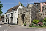
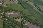
Dubris, also known as Portus Dubris and Dubrae, was a port in Roman Britain on the site of present-day Dover, Kent, England. As the closest point to continental Europe and the site of the estuary of the Dour, the site chosen for Dover was ideal for a cross-channel port. The Dour is now covered over for much of its course through the town. In the Roman era, it grew into an important military, mercantile and cross-channel harbour and — with Rutupiae (Richborough Roman fort) — one of the two starting points of the road later known as Watling Street. It was fortified and garrisoned initially by the Classis Britannica, and later by troops based in a Saxon Shore Fort.
Excerpt from the Wikipedia article Dubris (License: CC BY-SA 3.0, Authors, Images).Dubris
Upper Road,
Geographical coordinates (GPS) Address Website Nearby Places Show on map
Geographical coordinates (GPS)
| Latitude | Longitude |
|---|---|
| N 51.1285 ° | E 1.323 ° |
Address
Dover Castle
Upper Road
CT16 1HW , Clarendon
England, United Kingdom
Open on Google Maps


