place

Wildenmannlisloch

1906 archaeological discoveriesAppenzell AlpsCaves of SwitzerlandLimestone cavesMousterian
Toggenburg
Eingang Wildmannlisloch

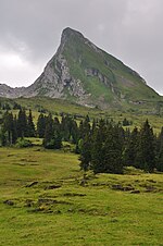
Wildenmannlisloch (also Wildmannlisloch, translating to "wild man's hole") is an alpine limestone Karst cave in the municipality of Wildhaus-Alt St. Johann, Toggenburg region, canton of St. Gallen, Switzerland, on the northern slope of the Churfirsten range (ca. 2 km due north of peak Selun) at an elevation of 1640 m. The cave extends for 142 m, at about 60 m from the entrance forming a chamber. The cave's name is recorded in 1819 a booklet on "Zwingli's birthplace" (Zwinglis Geburtsort, i.e. Wildhaus) by J. Fr. Franz: "at the foot of Selun ridge there is a great cave, known as the wild man's hole, which at first is very broad and high, so that it could by entered by horse and wagon, then becomes narrower, and again wider, and in such alternation continues along various bends for a quarter of an hour before its end is reached." An examination of 15 July 1906 yielded bones of cave bears. A more detailed survey was conducted during 1923 to 1928 (published in Bächler 1934), producing a large number of bones, mostly of bears, besides a smaller number of stone tools comparable to the Wildkirchli finds. The bones seem to have been artificially deposited in heaps. The cave was presumably in use (either inhabited or used as a storage site for meat, or as a sacrificial site) by prehistoric man during the Mousterian (about 40,000 to 35,000 years ago). Johannes Seluner, a feral child found in 1844, presumably lived in the cave during a number of years.

Excerpt from the Wikipedia article Wildenmannlisloch (License: CC BY-SA 3.0, Authors, Images).

Wildenmannlisloch
Breitenalpstrasse, Wildhaus-Alt St. Johann

Geographical coordinates (GPS) Address External links Nearby Places
placeShow on map

Wikipedia: WildenmannlislochContinue reading on Wikipedia

Geographical coordinates (GPS)

Latitude Longitude
N 47.167777777778 ° E 9.2552777777778 °
placeShow on map

Address

Wildmannlisloch

Breitenalpstrasse
9656 Wildhaus-Alt St. Johann
St. Gallen, Switzerland
mapOpen on Google Maps

linkWikiData (Q2570600)
linkOpenStreetMap (793164907)

Eingang Wildmannlisloch
Share experience

Nearby Places

St. John's Abbey in the Thurtal

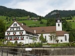
St. John's Abbey in the Thurtal (German: Kloster St. Johann im Thurtal) was a Benedictine monastery originally established in Alt St. Johann in the Canton of St. Gallen, Switzerland, in the mid-12th century. The oldest written record of it is dated 4 October 1152, when Pope Eugene III took the monastery into his protection. The pope confirmed the monastery's possessions and free election of its abbot and Vogt. On 24 October 1178 Pope Alexander III confirmed the abbey's extended possessions. In 1227/1228, the king became Vogt of the abbey. In December 1231, Emperor Frederick II issued a Golden Bull confirming his obligations as Vogt of the abbey. The abbey owned numerous estates in Toggenburg and in the Rhine valley: St. Johann, Stein, Nesslau, Kappel, St. Peterzell and Mogelsberg; and in Vorarlberg in Austria, near Feldkirch, in Klaus, Götzis and Altach.The abbey also frequently bought land in the territory which is now the principality of Liechtenstein, most notably the prominent Red House in Vaduz, which it purchased in 1525 from the heirs of the medieval owners, the Vaisli family.The abbey's high point was during the 14th century. It survived the Reformation, but lost its independence in 1555, when it became a priory of St. Gall's Abbey.In 1626 the buildings were severely damaged by fire, and the monks were afflicted by a mysterious illness and the community moved along the valley to a new location at Sidwald near Nesslau, since then known as Neu St. Johann. On the site of the old monastery a parish church was built, with a priest's house.The new monastery buildings in Nesslau, which were completed by 1680, were in a magnificent Rococo style. Toggenburg was an area of mixed denominations, and the priory was an instrument of the Counter-Reformation under the leadership of the Prince-Abbots of St. Gallen.The priory was dissolved in 1805. The former monastic church became the Roman Catholic parish church of the parish of Neu St. Johann. The remaining buildings now accommodate a remedial educational centre known as the Johanneum.

Churfirsten
Churfirsten

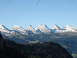
Churfürsten is a mountain range in the Canton of St. Gallen, Switzerland. They form the natural boundary between the canton's Toggenburg and Sarganserland districts. They are the southernmost range of the Appenzell Alps, separated from the Glarus Alps by the Seez river and Walensee. They consist of a limestone ridge running east to west, with the individual peaks formed by erosion. The ridge is defined much more sharply to the south than to the north, with an almost vertical drop of several hundred meters towards Walenstadtberg and eventually Lake Walensee at 419 m. The southern slope of the range was significantly formed by the Rhine Glacier during the Würm glaciation. The name is a plural, indicating the peaks forming the historical boundary of the bishopric of Chur. It has historically also been folk-etymologized as Kurfürsten, i.e. the 7 prince-electors of the Holy Roman Empire who in the later medieval period (until 1648) numbered seven, which in turn encouraged the count of seven main or "official" peaks.The standard "seven peaks" of the Churfürsten are (from west to east): Selun (2205 m) Frümsel (2263 m) Brisi (2279 m) Zuestoll (2235 m) Schibenstoll (2234 m) Hinterrugg (2306 m) Chäserrugg (2262 m)The count of exactly seven peaks is contrived; sometimes, Chäserrugg is not included and counted as part of Hinterrugg, because of its topographical prominence of a mere 14 m. The Churfürsten seven peaks listed above have remarkably uniform heights (within just above a 100 m difference); the ridge continues both to the east and the west with a number of further peaks between 2000 and 2200 m that are not usually included as Churfürsten: Peaks to the west of Selun: Wart (2068 m), Schären (or Schäären, 2184 m), Nägeliberg (2153 m), Glattchamm (2084 m), Leistchamm (2101 m). Peaks to the east of Chäserrugg: Tristenkolben (2159 m), Gamserrugg (2076 m).