Sundridge with Ide Hill

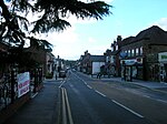
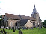
Sundridge and Ide Hill is a civil parish in the Sevenoaks District of Kent, England. It is located in the Darenth valley and lies between Sevenoaks and Westerham. The parish contains the villages of Sundridge and Ide Hill and the hamlet of Goathurst Common. It lies within the Kent Downs Area of Outstanding Natural Beauty and within London's Metropolitan Green Belt. It is approximately 21 miles south of London. The parish was created in 1973, when the settlements of Sundridge and Ide Hill were merged into a parish. Between the two villages is Emmetts Garden, a National Trust property. According to the 2011 census, the total population of the parish was 1,877. Of that total, there were 917 males and 960 females living in the parish.
Excerpt from the Wikipedia article Sundridge with Ide Hill (License: CC BY-SA 3.0, Authors, Images).Sundridge with Ide Hill
Spode Lane,
Geographical coordinates (GPS) Address Nearby Places Show on map
Geographical coordinates (GPS)
| Latitude | Longitude |
|---|---|
| N 51.1642 ° | E 0.0739 ° |
Address
Spode Lane
TN8 7HP
England, United Kingdom
Open on Google Maps


