place

Floriańska Street

13th-century establishments in PolandStreets in KrakówTourist attractions in Kraków
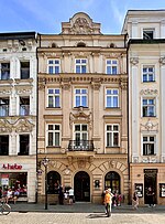
Floriańska street (view from N), Old Town, Krakow, Poland

Floriańska Street or St. Florian's Street (Polish: ulica Floriańska, Latin: platea Sancti Floriani) is one of the main streets in Kraków Old Town and one of the most famous promenades in the city. The street forms part of the regular grid plan of Stare Miasto (the Old Town), the merchants' town that extends the medieval heart of the city, which was drawn up in 1257 after the destruction of the city during the first Mongol invasion of Poland of 1241.

Excerpt from the Wikipedia article Floriańska Street (License: CC BY-SA 3.0, Authors, Images).

Floriańska Street
Floriańska, Krakow Stare Miasto (Old Town)

Geographical coordinates (GPS) Address Nearby Places
placeShow on map

Wikipedia: Floriańska StreetContinue reading on Wikipedia

Geographical coordinates (GPS)

Latitude Longitude
N 50.0633 ° E 19.9402 °
placeShow on map

Address

Floriańska 25
31-019 Krakow, Stare Miasto (Old Town)
Lesser Poland Voivodeship, Poland
mapOpen on Google Maps

Floriańska street (view from N), Old Town, Krakow, Poland
Share experience

Nearby Places

Pharmacy Museum of the Jagiellonian University Medical College

Muzeum Farmacji Collegium Medicum Uniwersytetu Jagiellońskiego (Pharmacy Museum, Jagiellonian University Medical College) is a museum on Floriańska Street, Kraków, Poland, specializing in the history of pharmacy and pharmaceutical technology. It was established in 1946. The founder and first director of the museum was Dr. Stanislaw Pron, legal counsel and administrative director of the Regional Chamber of Pharmacists in Kraków. Until the late 1980s, the museum was housed in the building at 3 ul. Basztowa. It was then transferred to the newly renovated building at ul. St. Florian's, where it remains today. The museum occupies all five floors of the building, including the basement and the attic, in a manner appropriate to the historical use of such premises in as an apothecary. On the first floor is a room dedicated to Ignacy Łukasiewicz, a pharmacist, pioneer in the field of crude oil, and the inventor of the modern kerosene lamp. The room on the second floor of the exhibition is devoted to Tadeusz Pankiewicz, a Roman Catholic who ran the "Under the Eagle" pharmacy in the Kraków Ghetto during the Nazi occupation of Poland. Among the various exhibits of pharmaceutical technology are weights of less than one gram as patented by Marian Zahradnik, the shape of which indicates their importance. Such weights were adopted in the countries of the Austro-Hungarian Empire and later across Europe, and are still used with minor modifications. Another interesting invention is an electrical device to sterilize prescriptions. It was to protect the pharmacist from infection by germs transferred on the prescription.

Lesser Poland Voivodeship

Lesser Poland Voivodeship or Lesser Poland Province (in Polish: województwo małopolskie [vɔjɛˈvut͡stfɔ mawɔˈpɔlskʲɛ]), also known as Małopolska, is a voivodeship (province), in southern Poland. It has an area of 15,108 square kilometres (5,833 sq mi), and a population of 3,404,863 (2019).It was created on 1 January 1999 out of the former Kraków, Tarnów, Nowy Sącz and parts of Bielsko-Biała, Katowice, Kielce and Krosno Voivodeships, pursuant to the Polish local government reforms adopted in 1998. The province's name recalls the traditional name of a historic Polish region, Lesser Poland, or in Polish: Małopolska. Current Lesser Poland Voivodeship, however, covers only a small part of the broader ancient Małopolska region which, together with Greater Poland (Wielkopolska) and Silesia (Śląsk), formed the early medieval Polish state. Historic Lesser Poland is much larger than the current province. It stretches far north, to Radom, and Siedlce, also including such cities, as Stalowa Wola, Lublin, Kielce, Częstochowa, and Sosnowiec. The province is bounded on the north by the Świętokrzyskie Mountains (Góry Świętokrzyskie), on the west by Jura Krakowsko-Częstochowska (a broad range of hills stretching from Kraków to Częstochowa), and on the south by the Tatra, Pieniny and Beskidy Mountains. Politically it is bordered by Silesian Voivodeship to the west, Świętokrzyskie Voivodeship to the north, Subcarpathian Voivodeship to the east, and Slovakia (Prešov Region and Žilina Regions) to the south. Almost all of Lesser Poland lies in the Vistula River catchment area. The city of Kraków was one of the European Cities of Culture in 2000. Kraków has railway and road connections with Katowice (expressway), Warsaw, Wrocław and Rzeszów. It lies at the crossroads of major international routes linking Dresden with Kyiv, and Gdańsk with Budapest. Located here is the second largest international airport in Poland (after Warsaw's), the John Paul II International Airport.