place

Veit Stoss altarpiece in Kraków

AltarpiecesSculptures by Veit StossTourist attractions in KrakówWooden sculptures in Poland
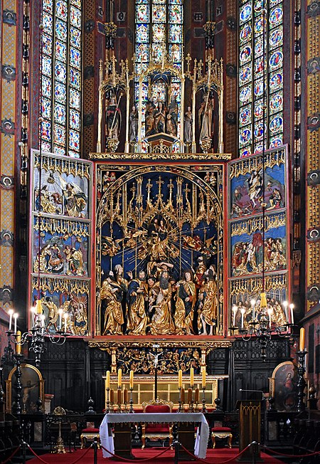
Church of Our Lady Assumed into Heaven, St. Mary's (Main) Altar (1489 by Veit Stoss), 5 Mariacki square, Old Town, Kraków, Poland

The Altarpiece by Veit Stoss (Polish: Ołtarz Wita Stwosza), also St. Mary's Altar (Ołtarz Mariacki), is a large Gothic altarpiece and a national treasure of Poland. It is located behind the high altar of St. Mary's Basilica in the city of Kraków. The altarpiece was carved between 1477 and 1489 by the German-born sculptor Veit Stoss (known in Polish as Wit Stwosz) who lived and worked in the city for over 20 years. In 1941, during the German occupation, the dismantled altarpiece was shipped to the Third Reich on the order of Hans Frank – the Governor-General of that part of occupied Poland. It was recovered in 1946 in Bavaria, hidden in the basement of the heavily bombed Nuremberg Castle. The High Altar underwent major restoration work in Poland and was put back in its place at the Basilica 10 years later.

Excerpt from the Wikipedia article Veit Stoss altarpiece in Kraków (License: CC BY-SA 3.0, Authors, Images).

Veit Stoss altarpiece in Kraków
Plac Mariacki, Krakow Stare Miasto (Old Town)

Geographical coordinates (GPS) Address Website Nearby Places
placeShow on map

Wikipedia: Veit Stoss altarpiece in KrakówContinue reading on Wikipedia

Geographical coordinates (GPS)

Latitude Longitude
N 50.061667 ° E 19.939167 °
placeShow on map

Address

Kościół pw. Wniebowzięcia Najświętszej Marii Panny (Bazylika pw. Wniebowzięcia Najświętszej Maryi Panny)

Plac Mariacki
31-042 Krakow, Stare Miasto (Old Town)
Lesser Poland Voivodeship, Poland
mapOpen on Google Maps

Website
mariacki.com

linkVisit website

Church of Our Lady Assumed into Heaven, St. Mary's (Main) Altar (1489 by Veit Stoss), 5 Mariacki square, Old Town, Kraków, Poland
Share experience

Nearby Places

Lesser Poland Voivodeship

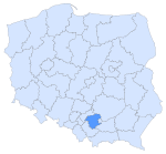
Lesser Poland Voivodeship or Lesser Poland Province (in Polish: województwo małopolskie [vɔjɛˈvut͡stfɔ mawɔˈpɔlskʲɛ]), also known as Małopolska, is a voivodeship (province), in southern Poland. It has an area of 15,108 square kilometres (5,833 sq mi), and a population of 3,404,863 (2019).It was created on 1 January 1999 out of the former Kraków, Tarnów, Nowy Sącz and parts of Bielsko-Biała, Katowice, Kielce and Krosno Voivodeships, pursuant to the Polish local government reforms adopted in 1998. The province's name recalls the traditional name of a historic Polish region, Lesser Poland, or in Polish: Małopolska. Current Lesser Poland Voivodeship, however, covers only a small part of the broader ancient Małopolska region which, together with Greater Poland (Wielkopolska) and Silesia (Śląsk), formed the early medieval Polish state. Historic Lesser Poland is much larger than the current province. It stretches far north, to Radom, and Siedlce, also including such cities, as Stalowa Wola, Lublin, Kielce, Częstochowa, and Sosnowiec. The province is bounded on the north by the Świętokrzyskie Mountains (Góry Świętokrzyskie), on the west by Jura Krakowsko-Częstochowska (a broad range of hills stretching from Kraków to Częstochowa), and on the south by the Tatra, Pieniny and Beskidy Mountains. Politically it is bordered by Silesian Voivodeship to the west, Świętokrzyskie Voivodeship to the north, Subcarpathian Voivodeship to the east, and Slovakia (Prešov Region and Žilina Regions) to the south. Almost all of Lesser Poland lies in the Vistula River catchment area. The city of Kraków was one of the European Cities of Culture in 2000. Kraków has railway and road connections with Katowice (expressway), Warsaw, Wrocław and Rzeszów. It lies at the crossroads of major international routes linking Dresden with Kyiv, and Gdańsk with Budapest. Located here is the second largest international airport in Poland (after Warsaw's), the John Paul II International Airport.

Kraków Voivodeship (14th century – 1795)

Kraków Voivodeship 1300–1795 (Latin: Palatinatus Cracoviensis, Polish: Województwo Krakowskie) – a unit of administrative division and local government in the Kingdom of Poland from the 14th century to the partitions of Poland in 1772–1795 (see History of Poland during the Piast dynasty, Kingdom of Poland (1385–1569), and Polish–Lithuanian Commonwealth). Located in the southwestern corner of the country, it was part of the Little Poland province (together with two other ancient voivodeships of Poland – Sandomierz Voivodeship, and Lublin Voivodeship). Kraków Voivodeship emerged from the Duchy of Kraków, which was created as Seniorate Province in the Testament of Bolesław III Krzywousty (1138). According to Zygmunt Gloger, it was one of the richest provinces of the Kingdom of Poland, with salt mines in Bochnia and Wieliczka, silver and lead mines in Olkusz, and very fertile soil around Proszowice. Its boundaries changed little for centuries. In 1457, the Duchy of Oświęcim was incorporated into the voivodeship, in 1564 – the Duchy of Zator (the Silesian County was created out of the two), and in 1790, the Duchy of Siewierz. Among cities and towns of contemporary Poland, which were part of Kraków Voivodeship, are Będzin, Biała, Bochnia, Brzesko, Częstochowa, Dąbrowa Górnicza, Jasło, Jaworzno, Jędrzejów, Krzepice, Kłobuck, Miechów, Nowy Sącz, Nowy Targ, Oświęcim, Sosnowiec, Szczekociny, Zakopane, Zator, Zawiercie, and Żywiec. In the first partition of Poland, in 1772 Habsburg monarchy annexed southern half of the voivodeship (south of the Vistula). In 1795, the third and final partition of Poland, Austria annexed the remaining part of the province, with the exception of its northwestern corner (around Częstochowa), which was seized by the Kingdom of Prussia, as New Silesia. Zygmunt Gloger in his monumental book Historical Geography of the Lands of Old Poland gives a detailed description of Kraków Voivodeship: Kraków Voivodeship covered Subcarpathian Lechia on the right bank of the Vistula, as well as land on the left bank of the river, between Kraków and Sieradz, where the Warta and the Pilica have their sources. Little is known about early history of southern areas of this province, and our knowledge is based on legends. We know that there was a prince named Krakus or Krak, after whom the city of Kraków was named (...) Local tribes, which remained pagan, were separated from the world by the Carpathians, so there are no documents about their origins (...) During the reign of Duke Mieszko I, the Bohemia state reached as far as Kraków, which was annexed by Bolesław Chrobry in 999 (...) In 1138, following the Testament of Bolesław III Krzywousty, the Duchy of Kraków was granted to Wladyslaw, the eldest son of Krzywousty. Boundaries of the duchy were most likely the same as boundaries of Kraków Voivodeship. In 1397, three counties were created: Kraków, Proszowice and Zarnowiec. In the 16th century, there were seven counties in the voivodeship: Proszowice, Szczyrzyc, Lelów, Książ Wielki, Silesian, Biecz and Nowy Sącz (...) Boundaries of Kraków Voivodeship were as follows: in the north it partly went along the Liswarta river, crossing the Pilica between Koniecpol and Lelów. The towns of Secemin, Sobków, Pińczów, Opatowiec, Szczurowa, Wojnicz, Tuchów, Brzostek, Kołaczyce and Jedlicze belonged to Sandomierz Voivodeship, while Lelów, Jędrzejów, Działoszyce, Skalbmierz, Koszyce, Szczepanów, Zakliczyn, Jodłowa, Jasło, Dukla and Jaśliska were part of Kraków Voivodeship. Southern border was marked by the mountains, beyond which lies Spis (...) In the west, Kraków Voivodeship included three Silesian duchies, namely Duchy of Oświęcim (since 1457), Duchy of Zator (since 1494) and Duchy of Siewierz (since 1443) (...) In the 16th century, Kraków Voivodeship had the area of 3,451 square miles, with 466 Roman-Catholic parishes, 71 towns and cities, and 2,206 villages (...) It had seven senators: the Bishop of Kraków, the Castellan of Kraków, the Voivode of Kraków, the Castellan of Wojnicz, and Castellans of Nowy Sącz, Biecz and Oświęcim. Starostas resided in such locations, as Kraków, Sacz, Biecz, Spisz, Badzyn, Czchow, Czorsztyn, Dębowiec, Dobczyce, Grybów, Jadowniki, Jodłowa, Jasło, Krzeczow, Lanckorona, Lelów, Libiąż, Mszana Dolna, Nowy Targ, Olsztyn, Ojców, Rabsztyn, Wolbrom, and others. Local sejmik took place at Proszowice, where eight deputies were elected to the Sejm and Lesser Poland Tribunal in Lublin (...) The Duchies of Oświęcim and Zator had their own sejmik at Zator, electing two deputies. These two Duchies had 160 villages, and six towns (Oświęcim, Zator, Żywiec, Kęty, Wadowice and Berwald). The Duchy of Siewierz, which belonged to Bishops of Kraków, had two towns (Siewierz and Sławków) (...) Kraków Voivodeship was regarded as the richest part of the Kingdom of Poland. It was the favourite province of King Kazimierz Wielki, and during the reign of the Jagiellon dynasty, a great number of palaces and castles was built here. Kraków Voivodeship had plenty of old churches, chapels, tombs, and other historical buildings (...) Among popular places there were Cistercial Abbey at Mogila near Kraków, Benedictine Abbey at Tyniec, Jasna Góra Monastery at Częstochowa, Franciscan church and abbey at Stary Sącz. Among major castles were Tenczyn Castle, Lipowiec Castle, Siewierz Castle, Smolen Castle, Bobolice Castle, Czorsztyn Castle, Olsztyn Castle, Ojców Castle, Pieskowa Skała Castle, Wojnicz Castle, Stará Ľubovňa Castle and others. Voivodeship Governor (Wojewoda) seat: KrakówSejmiks (or territorial) seat: ProszowiceRegional council (sejmik generalny) seat: Nowe Miasto Korczyn
Pharmacy Museum of the Jagiellonian University Medical College

Muzeum Farmacji Collegium Medicum Uniwersytetu Jagiellońskiego (Pharmacy Museum, Jagiellonian University Medical College) is a museum on Floriańska Street, Kraków, Poland, specializing in the history of pharmacy and pharmaceutical technology. It was established in 1946. The founder and first director of the museum was Dr. Stanislaw Pron, legal counsel and administrative director of the Regional Chamber of Pharmacists in Kraków. Until the late 1980s, the museum was housed in the building at 3 ul. Basztowa. It was then transferred to the newly renovated building at ul. St. Florian's, where it remains today. The museum occupies all five floors of the building, including the basement and the attic, in a manner appropriate to the historical use of such premises in as an apothecary. On the first floor is a room dedicated to Ignacy Łukasiewicz, a pharmacist, pioneer in the field of crude oil, and the inventor of the modern kerosene lamp. The room on the second floor of the exhibition is devoted to Tadeusz Pankiewicz, a Roman Catholic who ran the "Under the Eagle" pharmacy in the Kraków Ghetto during the Nazi occupation of Poland. Among the various exhibits of pharmaceutical technology are weights of less than one gram as patented by Marian Zahradnik, the shape of which indicates their importance. Such weights were adopted in the countries of the Austro-Hungarian Empire and later across Europe, and are still used with minor modifications. Another interesting invention is an electrical device to sterilize prescriptions. It was to protect the pharmacist from infection by germs transferred on the prescription.