place

Southern Stove Works, Manchester

Buildings and structures in Richmond, VirginiaIndustrial buildings and structures on the National Register of Historic Places in VirginiaIndustrial buildings completed in 1920National Register of Historic Places in Richmond, VirginiaRichmond, Virginia Registered Historic Place stubs
Stoves
SouthernStoveWorksManchester

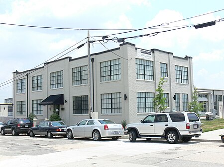
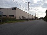
Southern Stove Works, Manchester is a historic factory complex located in Richmond, Virginia that replaced the company's original factory. The complex includes two contributing prefabricated steel frame buildings built in 1920. The west building contains the original two-story office building that has been connected by one-story infill to the long one-story warehouse building that contained the pressing and mounting departments and a three-part warehouse. The office is a five-by-three-bay, two-story, building measuring 40 by 80 feet (12 by 24 m) and brick curtain walls. The east building today consists of the foundry with attached original washrooms and office, charging room, and an expanded mill room.It was listed on the National Register of Historic Places in 2008.

Excerpt from the Wikipedia article Southern Stove Works, Manchester (License: CC BY-SA 3.0, Authors, Images).

Southern Stove Works, Manchester
East 6th Street, Richmond Manchester

Geographical coordinates (GPS) Address Nearby Places
placeShow on map

Wikipedia: Southern Stove Works, ManchesterContinue reading on Wikipedia

Geographical coordinates (GPS)

Latitude Longitude
N 37.517777777778 ° E -77.4325 °
placeShow on map

Address

New Manchester Flats

East 6th Street 720
23224 Richmond, Manchester
Virginia, United States
mapOpen on Google Maps

SouthernStoveWorksManchester
Share experience

Nearby Places

Mayo Bridge
Mayo Bridge

Mayo's Bridge (also known as Richmond's 14th St. Bridge) is located in Richmond, Virginia. A four lane structure, it transports U.S. Route 360 across the James River. Signage identifies the bridge as "Mayo's Bridge". The bridge is in two sections, separated near the middle by Mayo's Island. The total length is 1,374 feet (north and south sections combined). The current structure was built in 1913, and accommodated heavy streetcar traffic. It is Richmond's oldest highway bridge across the James River. Prior to the construction of Mayo's Bridge, travelers had to utilize Coutts' Ferry, run by Patrick Coutts until his death in 1776 and later by his brother Rev. William Coutts until his death in 1787. The ferry landing was at a place called the "Sandy Bar" at the end of 18th Street. The ferry was kept up for many years after the bridge was built as the 6.25¢ toll was impressive and the bridge was often broken, thus necessitating the ferry. Patrick Coutts was something of a legend in old Richmond. This stemmed from the story that he had crossed the river not by ferry or bridge, but by sturgeon.Many people petitioned the Virginia Assembly for the right to build a bridge, but none were successful in receiving permission. Around the mid-1780s, John Mayo, son of William Mayo (the man who had laid out the plan for Richmond), was given the opportunity to build a toll bridge but died soon after. His son, John Mayo Jr., inherited his estate and finally completed the first bridge across the James in 1788. This bridge was very rudimentary and consisted of “large logs, raft-like, spiked to the rocks, with rough floor laid on the logs” on the north side of Mayo's Island and of a pontoon bridge that had planks laid on top of a series of boats on the south side. This bridge was destroyed the winter after its completion by ice floes dragging the bridge away. It was destroyed and subsequently rebuilt in 1814, 1816, 1823, 1865, 1870, 1877, 1882, and 1899. It was built on the site of the city's first bridge completed in 1788 by John Mayo Jr., the grandson of the man who first laid out Richmond's grid pattern. During the American Civil War the bridge was burned by retreating Confederate soldiers on April 8, 1865.In 1882, the a portion of the bridge collapsed with nine people on it; however, no one was killed or badly hurt in the incident.Rising just 30 feet above the water line, Mayo's Bridge is currently Richmond's only bridge subject to flooding. Large floodgates in Richmond's flood wall protect the surrounding areas on each side during James River flooding. The bridge's closeness to the river surface has made the sidewalks on either side of it popular fishing locations.
Manchester, Richmond, Virginia

Manchester is a former independent city in Virginia in the United States. Prior to receiving independent status, it served as the county seat of Chesterfield County, between 1870 and 1876. Today, it is a part of the city of Richmond, Virginia. Originally known as Manastoh and later Rocky Ridge, it was located on the south bank of the James River at the fall line opposite the state capital city of Richmond, on the north side of the river. Manchester was an active port city, and was a port of entry for slave ships principally in the 18th century. The port shipped out tobacco and coal which was transported 13 miles overland from the Midlothian-area mines on the Midlothian Turnpike, first paved toll road in Virginia in 1807, and the Chesterfield Railroad, the state's first in 1831. Manchester became an incorporated town in 1769 and an independent city in 1874. In 1910, it merged by mutual agreement with the larger state capital City of Richmond, achieving another "first" as the earliest of Virginia's independent cities to lose its identity. Today, "Old Manchester" is considered a neighborhood of Richmond. Many vestiges of its past are clearly visible, notably the courthouse, the Hull Street business district, a number of historic houses, and several former railroad and street railway buildings. As part of the community's African American heritage, a "slave trail" traces the route into the downtown area from where the slave ships docked along the river. Interstate 95, and four other major highways, U.S. Routes 1, 60, 301 and 360 all cross the James River and enter downtown Richmond from Manchester.

Triple Crossing
Triple Crossing

Triple Crossing in Richmond, Virginia is one of two places in North America where three Class I railroads cross at different levels at the same spot, the other being Santa Fe Junction in Kansas City. At the lowest (ground) level, the original Richmond and York River Railroad was extended after the American Civil War to connect with the Richmond and Danville Railroad, later part of the Southern Railway System, currently part of Norfolk Southern. The line runs east to West Point, Virginia. The middle level was the main line of the Seaboard Air Line Railroad, now part of CSX Transportation known as the "S" line, just south of Main Street Station. It is planned to become part of the Southeast High Speed Rail Corridor. At the top level is the Peninsula Subdivision Trestle, a 3-mile-long (4.8 km) viaduct parallel to the north bank of the James River built by the Chesapeake and Ohio Railway in 1901 to link the former Richmond and Allegheny Railroad with C&O's Peninsula Subdivision to Newport News and export coal piers. The viaduct, now owned by CSX Transportation, provided an alternate path to the notoriously unstable Church Hill Tunnel which buried a work train with fatalities on October 2, 1925. A locomotive and ten flat cars remain entombed with at least one rail worker, killing several others whose bodies were eventually recovered. The triple crossing has been a Richmond attraction for railfans for over 100 years, although the number of photographic angles decreased in the 1990s due to a new flood wall.