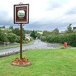
Welsh St Donats
Communities in the Vale of GlamorganGeography of GlamorganVillages in the Vale of Glamorgan

Welsh St Donats (Welsh: Llanddunwyd) is a village and a community in the Vale of Glamorgan, Wales. Consisting of 1207 hectares of mainly rural land, it is located north east of Cowbridge. The population of the community was 534 in the 2011 census. Welsh St Donats includes the villages of Maendy, Prisk and Tair Onen. A mile to the east from the village lies the Hensol Forest, while the remains of Talyfan Castle are to the north.
Excerpt from the Wikipedia article Welsh St Donats (License: CC BY-SA 3.0, Authors, Images).Welsh St Donats
Watery Lane,
Geographical coordinates (GPS) Address Nearby Places Show on map
Geographical coordinates (GPS)
| Latitude | Longitude |
|---|---|
| N 51.475088 ° | E -3.401187 ° |
Address
Watery Lane
Watery Lane
CF71 7SU , Welsh St. Donats
Wales, United Kingdom
Open on Google Maps


