place

Quirino Avenue

Malate, ManilaPaco, ManilaPandacanStreets in ManilaUse Philippine English from March 2023
Use mdy dates from March 2023
Quirino Avenue
Quirino Avenue

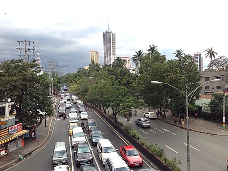
President Elpidio Quirino Avenue, more commonly known as Quirino Avenue, is a 6-10 lane divided highway in Manila, Philippines. It runs for 3.6 kilometers (2.2 mi) in a northeast–southwest direction from Nagtahan Bridge (now Mabini Bridge) across from Santa Mesa in the north to Roxas Boulevard in Malate in the south. It passes through Paco and Pandacan districts where it also serves as a truck route between Port Area and South Luzon Expressway. North of Nagtahan Bridge, the road continues as Nagtahan Street. It is designated as part of Circumferential Road 2.

Excerpt from the Wikipedia article Quirino Avenue (License: CC BY-SA 3.0, Authors, Images).

Quirino Avenue
President Quirino Avenue, Manila Paco (Fifth District)

Geographical coordinates (GPS) Address Nearby Places
placeShow on map

Wikipedia: Quirino AvenueContinue reading on Wikipedia

Geographical coordinates (GPS)

Latitude Longitude
N 14.575833333333 ° E 120.99611111111 °
placeShow on map

Address

President Quirino Avenue
1007 Manila, Paco (Fifth District)
Philippines
mapOpen on Google Maps

Quirino Avenue
Quirino Avenue
Share experience

Nearby Places

Metro Manila
Metro Manila

Metropolitan Manila (Filipino: Kalakhang Maynila), formally the National Capital Region (NCR; Filipino: Pambansang Punong Rehiyon) and commonly called Metro Manila, is the capital region and largest metropolitan area of the Philippines. The region is located on the eastern shore of Manila Bay, between the Central Luzon and Calabarzon regions. It consists of 16 highly urbanized cities: the City of Manila, Caloocan, Las Piñas, Makati, Malabon, Mandaluyong, Marikina, Muntinlupa, Navotas, Parañaque, Pasay, Pasig, Quezon City, San Juan, Taguig, and Valenzuela, and one municipality: Pateros. The region encompasses an area of 619.57 square kilometers (239.22 sq mi) and a population of 13,484,462 as of 2020. It is the second most populous and the most densely populated region in the Philippines. It is also the 9th most populous metropolitan area in Asia and the 6th most populous urban area in the world. The region is the center of culture (including arts and entertainment), economy, education and government of the Philippines. Designated as a global power city, the region exerts a significant impact on commerce, finance, media, art, fashion, research, technology, education, and entertainment, both locally and internationally. It is the home to all embassies in the Philippines, thereby making it an important center for international diplomacy in the country. Its economic power makes the region the country's premier center for finance and commerce. The region accounts for 36% of the gross domestic product (GDP) of the Philippines. Greater Manila is ASEAN fourth largest economy after Singapore, Jakarta and Bangkok. The metropolis was established in 1975 through Presidential Decree No. 824 in response to the needs to sustain the growing population and for the creation for the center of political power and the seat of the government of the Philippines. The Province of Manila, the predecessor entity of the region, is one of the first eight provinces that revolted against the Spanish colonial rule in the Philippines at the end of the 19th century. Manila's role in the Revolution is honoured in the flag of the Philippines, where the sun's eight rays symbolise the eight revolutionary provinces.