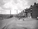
Harraton

Harraton is a former civil parish and now a suburb in the unparished area of the town of Washington, in the City of Sunderland metropolitan borough, in Tyne and Wear, England. Harraton is near the River Wear and is 3 miles north-east of Chester-le-Street, 2 miles south-west of Washington town centre and 9 miles south-southwest of Sunderland. When nearby Washington (historically a village) was founded as a new town under the New Towns Act in 1964, Harraton alongside the neighboring villages of Chaters-Hough, Fatfield, Cox Green and Picktree became suburbs of Washington forming the southern suburbs of the town. Certain developments also took place for overspill for the nearby towns of Chester Le Street and Houghton-le-Spring (also in the City of Sunderland metropolitan borough). It is on the main road serving Seahouses and the northern coast. In 1961 the parish had a population of 3,565.
Excerpt from the Wikipedia article Harraton (License: CC BY-SA 3.0, Authors, Images).Harraton
North Crescent, Sunderland
Geographical coordinates (GPS) Address Nearby Places Show on map
Geographical coordinates (GPS)
| Latitude | Longitude |
|---|---|
| N 54.881 ° | E -1.534 ° |
Address
North Crescent
North Crescent
NE38 9AJ Sunderland
England, United Kingdom
Open on Google Maps


