place

Weyers Cave School

1917 establishments in VirginiaAugusta County, Virginia geography stubsColonial Revival architecture in VirginiaNational Register of Historic Places in Augusta County, VirginiaSchool buildings completed in 1917
School buildings on the National Register of Historic Places in VirginiaSchools in Augusta County, VirginiaShenandoah Valley, Virginia Registered Historic Place stubs
Weyers Cave School
Weyers Cave School

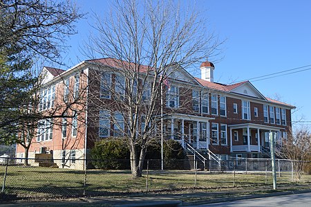
Weyers Cave School, also known as Weyer's Cave Elementary School, is a historic public school building located at Weyers Cave, Augusta County, Virginia. It was built in 1916–1917, and enlarged in 1923–1924. The original section consists of the northern entrance and hall with four-bay classroom blocks to each side. It exhibits a central-passage, double-pile plan. The addition is a four-room and passage block to the south. The Colonial Revival style is reflected in a one-story, one-bay wooden portico with Doric order columns and square balustrade.It was listed on the National Register of Historic Places in 1985.Weyers Cave School was closed as a school in 1993. Presently it is the site of Equipping the Saints, a non-profit organization shipping books, clothing, and technology to third world countries.

Excerpt from the Wikipedia article Weyers Cave School (License: CC BY-SA 3.0, Authors, Images).

Weyers Cave School
Keezletown Road,

Geographical coordinates (GPS) Address Nearby Places
placeShow on map

Wikipedia: Weyers Cave SchoolContinue reading on Wikipedia

Geographical coordinates (GPS)

Latitude Longitude
N 38.288055555556 ° E -78.909166666667 °
placeShow on map

Address

Weyers Cave Elementary School

Keezletown Road 1254
24486
Virginia, United States
mapOpen on Google Maps

Weyers Cave School
Weyers Cave School
Share experience

Nearby Places

North River (South Fork Shenandoah River tributary)

The North River is a 55.3-mile-long (89.0 km) river in the mountains and Shenandoah Valley of northern Virginia, the United States. It joins the South River at Port Republic to form the South Fork Shenandoah River. The river rises at 4,000 feet (1,200 m) above sea level in western Augusta County, below Dyers Knob on Shenandoah Mountain along the Virginia-West Virginia border. From the man-made Elkhorn Lake it flows south and then east through the George Washington National Forest. The river breaks out of the Allegheny Mountains at North River Gap and flows into the broad Valley of Virginia. The river passes through the town of Bridgewater and flows southeast, joining the South River at Port Republic. The Middle River, a major tributary, joins the North River just west of the town of Grottoes, four miles above the juncture with the South River. Other towns along the river include Mount Solon, Stokesville, Sangersville, Natural Chimneys, Mount Crawford, and the village of North River. The river is popular among canoeists, rafters and inner tubers. At one point during the 19th century barges shipped goods upstream via a canal/lock system. Typical wildlife of the North River includes the great blue heron, wood duck, Canada goose, belted kingfisher, Baltimore oriole, painted turtle, common snapping turtle, largemouth bass, sun perch, catfish, eastern cottontail rabbit, white-tailed deer, raccoon, opossum, brown bats, freshwater clams, mink, tiger swallowtail and ebony jewelwing. Typical plant life of the North River includes the cardinal flower, joe-pye weed, purple monkeyflower, great blue lobelia, bulrush, yellow iris, American sycamore, cottonwood, box-elder, silver maple, Virginia bluebells, and spring beauty.