place

All Saints' Church, Winthorpe

Church of England church buildings in NottinghamshireChurches completed in 1888Grade II listed churches in Nottinghamshire
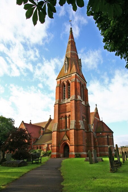
All Saints' Church, Winthorpe geograph.org.uk 653770

All Saints' Church, Winthorpe is a Grade II listed parish church in the Church of England in Winthorpe, Nottinghamshire, England. The current building, the construction of which was completed in 1888, is at least the third version of the church, which dates back to at least the early 13th century. All Saints' Church was commissioned by the church rector, Edward Handley, in memory of one of his relatives.

Excerpt from the Wikipedia article All Saints' Church, Winthorpe (License: CC BY-SA 3.0, Authors, Images).

All Saints' Church, Winthorpe
Gainsborough Road, Newark and Sherwood

Geographical coordinates (GPS) Address Nearby Places
placeShow on map

Wikipedia: All Saints' Church, WinthorpeContinue reading on Wikipedia

Geographical coordinates (GPS)

Latitude Longitude
N 53.098267833333 ° E -0.788653 °
placeShow on map

Address

Gainsborough Road
NG24 2NR Newark and Sherwood
England, United Kingdom
mapOpen on Google Maps

All Saints' Church, Winthorpe geograph.org.uk 653770
Share experience

Nearby Places

Langford, Nottinghamshire

Langford is a village and civil parish in Nottinghamshire, England. It is located four miles north-east of Newark-on-Trent and two miles East from The River Trent. Population details are included in the civil parish of Holme. It is based on A1133 which comes off of the A46. Although Langford is currently located two miles from The River Trent it has not always been this way. In "1575 there was a cataclysmic flood" which altered the course of the Trent which meant Langford and Holme were now on the same side of the river. Before this change in the rivers course the Trent used to flow next to St Bartholomew's church and Holme was on the opposite side of the bank. John Marius Wilson's Imperial Gazetteer of England and Wales (1870–72) records Langford as follows: Langford, a parish in Newark district, Notts; on the Newark and Lincoln railway, and on the Fosse way, near the river Trent, and near the boundary with Lincolnshire, 3 miles NNE of Newark r[ailway] station. Post-town, Newark. Acres, 2,182. Real property, £2,471. Pop., 161. Houses, 24. The manor and most of the land belong to Lord Middleton. Langford House is the seat of T. A. F. Burnaby, Esq. Bricks are made. A Roman settlement was here. The living is a p[erpetual] curacy, annexed to the vicarage of Holme, in the diocese of Lincoln. The church is a plain building, with a tower. The village gives its name to the nearby Langford Lowfields RSPB reserve, a tarmac and sand quarry that is gradually being transformed into a nature reserve with extensive reedbeds. The site is home to species such as sand martin, bearded tit and Cetti's warbler.