place

Moel Famau

Country parks in WalesEngvarB from September 2013Golden Jubilee of George IIIHighest points of Welsh countiesLlangynhafal
Marilyns of WalesMountains and hills of DenbighshireMountains and hills of FlintshirePages including recorded pronunciationsPages with Welsh IPAThomas Harrison buildings
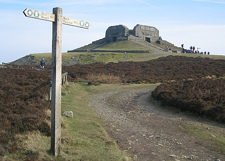
MoelFamauSummit(JohnSTurner)Feb2004

Moel Famau is the highest hill in the Clwydian Range and the highest point (county top) of the county of Flintshire in Wales (both the historic county and the current council area). It lies on the boundary between Denbighshire and Flintshire. The hill, which also gives its name to the Moel Famau country park, has been classed as an Area of Outstanding Natural Beauty since 1985. It is also surrounded by several well-preserved Iron Age hill forts. It is also the third-highest peak in the extended AONB of the Clwydian Range and Dee Valley. A northern part of the Offa's Dyke long-distance footpath, one of the UK's most popular National Trails, crosses the summit of Moel Famau and the Jubilee Tower. Loggerheads Country Park is nearby.

Excerpt from the Wikipedia article Moel Famau (License: CC BY-SA 3.0, Authors, Images).

Moel Famau
Offa's Dyke Way,

Geographical coordinates (GPS) Address Nearby Places
placeShow on map

Wikipedia: Moel FamauContinue reading on Wikipedia

Geographical coordinates (GPS)

Latitude Longitude
N 53.1545 ° E -3.2559 °
placeShow on map

Address

Jubilee Tower

Offa's Dyke Way
LL15 1TD
Wales, United Kingdom
mapOpen on Google Maps

MoelFamauSummit(JohnSTurner)Feb2004
Share experience

Nearby Places

Llanrhydd

Llanrhydd or Llanrhudd is a parish one and a half miles south-west of Ruthin in Denbighshire, Wales; 'rhudd' being the Welsh name for 'red' – the colour of the local sandstone. In a tiny rural hamlet a mile or so from the town centre, St Meugan's was the original mother-church of the Welsh settlement which became Ruthin. The pretty little 15th century building (dedicated to a hermit-saint from Caerleon in Gwent) contains many notable furnishings – above all the ‘rood screen’ which once supported a ‘rood’ or crucifix (also at Derwen). The church probably dates back to the early 1500s and is a fine example of local carpentry: richly carved with intricate tracery, with an ‘ivy-berry’ trail (which is a Vale of Clwyd speciality) along its upper rail. The Georgian west gallery opposite (for choir and ‘church band’) is an even rarer survival, and is dated 1721, as such galleries were generally removed by the Victorians. Also rare is the ornate 17th century altar table. On the walls nearby are the intriguing monuments of the Thelwall family, who came to Ruthin with their de Grey overlords. The oldest depicts Elizabeth John and Jane Thelwall with their ten sons and four daughters, all named and some holding skulls to show that they died before their parents. The ninth son Ambrose is again commemorated by a fine portrait bust: a courtier to three Stuart kings, he retired here in the ‘troublesome times’ of Republican rule and died in 1653. In the churchyard (not far from the south porch) stands the decorated nine-foot shaft of a medieval preaching cross: and in the north-east corner is the gravestone of ‘Alfred Corbett, Tramp’ a popular figure who died in 1947. A good guidebook is available in the church. St Meugan's church is open by appointment.

Clwydian Range and Dee Valley

The Clwydian Range and Dee Valley (Welsh: Bryniau Clwyd a Dyffryn Dyfrdwy) is a designated Area of Outstanding Natural Beauty (AONB) located in north-east Wales, covering the Clwydian Range (Welsh: Bryniau Clwyd), and the valley of the River Dee (Welsh: Afon Dyfrdwy). Designated in 1985 as the Clwydian Range AONB, and expanded to its current form in 2011, the Area of Outstanding Natural Beauty includes: medieval field systems, open heather moorland, prehistoric hillforts, limestone crags, broad leaved woodland, wooded valleys, and farmland. The AONB falls within the jurisdiction of the local authorities of Denbighshire, Flintshire, and Wrexham County Borough, with the majority, 80% of the AONB in Denbighshire, and the remaining 20% split evenly between the other two authorities. The AONB is the largest of only five AONBs in Wales, and one of the 46 in the United Kingdom. Additionally, it is one of only 8 protected areas of Wales. Long-distance footpaths; Offa's Dyke Path, and the Clwydian Way pass through the AONB. The area of the Clwydian Range and Dee Valley AONB is 390 km2 (150 sq mi), and has been proposed by the Welsh Government to be replaced by a North East Wales National Park, which would be Wales' fourth national park. The AONB is underlain by sedimentary rocks dating from the Ordovician, Silurian, and early Carboniferous period with Triassic age rocks on lower slopes. The highest peak in the AONB is at Moel Fferna, peaking at 630 m (2,070 ft). The mainly Silurian Clwydian Range supports rounded, heather-clad hill tops which provide habitats for scarce flora and fauna and are home to Iron Age hillforts. Several areas have been designated as Sites of Special Scientific Interest and Special Areas of Conservation, with the AONB also home to multiple listed buildings, scheduled monuments, and part of the Pontcysyllte Aqueduct and Canal UNESCO World Heritage Site. In 2018, an estimated 1.1 million people visited six key sites across the AONB, generating approximately £24.1 million to the Welsh economy, according to Natural Resources Wales. The earliest evidence of human occupation in the AONB is from stone tools dated between 30 and 40,000 years ago in caves near Tremeirchion, with the oldest human-made feature in the AONB being the mound, Gop Cairn. The area is now used for a range of recreational, tourism, and agricultural purposes.