Bwlch Penbarras

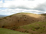
Bwlch Penbarras (also known as Bwlch Pen Barras, or the Old Bwlch) is a mountain pass in the Clwydian Range and Dee Valley Area of Outstanding Natural Beauty, in north-east Wales. The gap, which is at an altitude of 360 m (1,180 ft), lies between the hills of Moel Famau and Foel Fenlli. An unclassified road between Tafarn-y-Gelyn and Llanbedr-Dyffryn-Clwyd runs from east to west through the pass. Offa's Dyke Path, running broadly south–north, crosses the road at its highest point. The alternative name of Old Bwlch references its position on the historic route between Mold and Ruthin via Llanbedr Dyffryn Clwyd. It was superseded by the 18th-century Mold to Denbigh turnpike (now the A494 road), which crosses the Clwydian range several miles to the south, at Bwlch-y-Parc. The eastern side of Bwlch Penbarras is an almost straight ascent with no severe gradients; however, the western side of the pass is characterised by long drops, a narrower road and steep gradients: the road drops 260 m (850 ft) in 1.5 mi (2.4 km) with gradients approaching 25% and a sharp hairpin bend.
Excerpt from the Wikipedia article Bwlch Penbarras (License: CC BY-SA 3.0, Authors, Images).Bwlch Penbarras
Bwlch Penbarras,
Geographical coordinates (GPS) Address Nearby Places Show on map
Geographical coordinates (GPS)
| Latitude | Longitude |
|---|---|
| N 53.137 ° | E -3.251 ° |
Address
Bwlch Penbarras
Bwlch Penbarras
CH7 5SH , Llanferres
Wales, United Kingdom
Open on Google Maps


