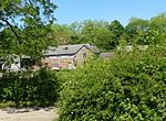
New Hall moated site
New Hall moated site is a scheduled monument in Tyldesley, Greater Manchester, England. The monument includes a moat and an island platform on which a modern house has been built. The island was the site of a medieval building. The moat measures between 20 and 30 metres across and is widest at the south west corner where the water soaks away to join a stream. The moat was revetted on the south side but the stonework is destroyed and is bridged on the same side by a modern stone bridge which replaced a timber structure. The rectangular island, measuring 60 metres by 40 metres, encloses an area of 0.25 hectares (0.62 acres) and is 0.4 metres above the surrounding land. Archaeological evidence of the medieval buildings will be present on the island and the moat will retain other environmental evidence. A ruined post-medieval farmhouse occupied a third of the island in 1983. The present modern buildings occupying the island are excluded from the scheduling, although the ground beneath them is part of the schedule.
Excerpt from the Wikipedia article New Hall moated site (License: CC BY-SA 3.0, Authors).New Hall moated site
Stour Road,
Geographical coordinates (GPS) Address Nearby Places Show on map
Geographical coordinates (GPS)
| Latitude | Longitude |
|---|---|
| N 53.506 ° | E -2.4546 ° |
Address
Stour Road
Stour Road
M29 7WS
England, United Kingdom
Open on Google Maps


