Raubsville, Pennsylvania
Census-designated places in Northampton County, PennsylvaniaCensus-designated places in PennsylvaniaPages with non-numeric formatnum argumentsPennsylvania geography stubsUse mdy dates from July 2023

Raubsville is a census-designated place in Williams Township, Pennsylvania. The population of Raubsville was 1,079 residents as of the 2020 census. Raubsville is located along PA Route 611 on the west bank of the Delaware River. It is part of the Lehigh Valley metropolitan area, which had a population of 861,899 and was the 68th-most populous metropolitan area in the U.S. as of the 2020 census. Raubsville is served by the Wilson Area School District, and students in grade nine through 12 attend Wilson Area High School. Raubsville uses the Easton ZIP Code of 18042.
Excerpt from the Wikipedia article Raubsville, Pennsylvania (License: CC BY-SA 3.0, Authors, Images).Raubsville, Pennsylvania
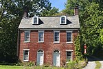
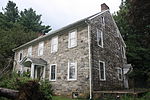
South Delaware Drive, Williams Township
Geographical coordinates (GPS) Address Nearby Places Show on map
Geographical coordinates (GPS)
| Latitude | Longitude |
|---|---|
| N 40.635555555556 ° | E -75.193055555556 ° |
Address
South Delaware Drive 2114
18042 Williams Township
Pennsylvania, United States
Open on Google Maps


