Epping Forest

Epping Forest is a 2,400-hectare (5,900-acre) area of ancient woodland, and other established habitats, which straddles the border between Greater London and Essex. The main body of the forest stretches from Epping in the north, to Chingford on the edge of the London built-up area. South of Chingford the forest narrows, and forms a green corridor that extends deep into East London, as far as Forest Gate; the Forest's position gives rise to its nickname, the Cockney Paradise. It is the largest forest in London.It lies on a ridge between the valleys of the rivers Lea and Roding. It contains areas of woodland, grassland, heath, streams, bogs and ponds, and its elevation and thin gravelly soil (the result of glaciation) historically made it less suitable for agriculture. The Forest was historically managed as a common; the land was held by a number of local landowners who exercised economic rights over aspects such as timber, while local commoners had grazing and other rights. It was designated a royal forest meaning that only the monarch had the right to hunt deer. The extensive urban areas on the Forest's doorstep bring many visitors to the Forest, and cause a strain on the Forest's ecology; however local recreational users of the Forest were crucial in saving the Forest when it was threatened with enclosure and destruction in the late 19th century. The huge public outcry led the City of London Corporation to buy and so save the site in what was the first major success of the environmental movement in Europe - the Corporation still owns the Forest. This environmental milestone came at a cost, as the City of London's early conservators did not understand the human processes that shaped the forest and its ecosystems, and discontinued the practice of pollarding trees while allowing grazing to decline. This changed the character of the Forest and has led to reduced biodiversity. The modern Conservators are mindful of these historic errors but it is probably not possible to reverse the effects of this long interruption of historic management methods.The Forest gives its name to the Epping Forest local government district, which covers part of it, and to Forest School, a private school in Walthamstow towards the south of it.
Excerpt from the Wikipedia article Epping Forest (License: CC BY-SA 3.0, Authors, Images).Epping Forest
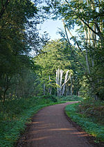
Green Ride, Epping Forest
Geographical coordinates (GPS) Address Nearby Places Show on map
Geographical coordinates (GPS)
| Latitude | Longitude |
|---|---|
| N 51.66 ° | E 0.05 ° |
Address
Loughton Camp
Green Ride
IG10 1HP Epping Forest
England, United Kingdom
Open on Google Maps


