Hadlow Down

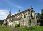
Hadlow Down is a village and civil parish in the Wealden District of East Sussex, England. It is located on the A272 road three miles (4.8 km) north-west of Heathfield. The parish is within the High Weald Area of Outstanding Natural Beauty. It came to prominence with the Wealden iron industry in the 17th and 18th centuries. The majority of the population now works outside the parish, but it still has a strong community atmosphere centred on the New Inn pub, St. Mark's school and St. Mark's church. The parish church, St. Mark's, was first built and consecrated in 1836 and rebuilt just before World War I. Edmond William Costello (1873–1949), holder of the Victoria Cross, is buried in the churchyard, and Diana Rowden (1915–44), SOE agent, lived at Hadlow Down before World War II. A former Calvinistic chapel, Providence Chapel, stands on Main Road; it was built in 1849 and converted into a house in 1996.The village school is St Mark's CE Primary School. The village pub is the New Inn, which is a historic Grade II listed building.
Excerpt from the Wikipedia article Hadlow Down (License: CC BY-SA 3.0, Authors, Images).Hadlow Down
Stockland Lane, Wealden Hadlow Down
Geographical coordinates (GPS) Address Nearby Places Show on map
Geographical coordinates (GPS)
| Latitude | Longitude |
|---|---|
| N 51 ° | E 0.18 ° |
Address
Stockland Lane
Stockland Lane
TN22 4EA Wealden, Hadlow Down
England, United Kingdom
Open on Google Maps


