place

Riverton, Connecticut

Census-designated places in ConnecticutCensus-designated places in Litchfield County, ConnecticutConnecticut geography stubsUse mdy dates from July 2023
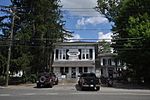
Riverton General Store, Riverton CT

Riverton is an unincorporated village and census-designated place (CDP) in the town of Barkhamsted, Litchfield County, Connecticut, United States. It is in the northwest corner of the town, bordered to the north by the town of Hartland in Hartford County. The village sits at the confluence of the Still River with the West Branch of the Farmington River. Riverton was first listed as a CDP prior to the 2020 census. 94 acres (0.38 km2) of the village center comprise the Riverton Historic District.

Excerpt from the Wikipedia article Riverton, Connecticut (License: CC BY-SA 3.0, Authors, Images).

Riverton, Connecticut
Mountain Road,

Geographical coordinates (GPS) Address Nearby Places
placeShow on map

Wikipedia: Riverton, ConnecticutContinue reading on Wikipedia

Geographical coordinates (GPS)

Latitude Longitude
N 41.962777777778 ° E -73.016666666667 °
placeShow on map

Address

Mountain Road 3
06065
Connecticut, United States
mapOpen on Google Maps

Riverton General Store, Riverton CT
Share experience

Nearby Places

Northeastern United States

The Northeastern United States, also referred to as the Northeast, the East Coast, or the American Northeast, is a geographic region of the United States located on the Atlantic coast of North America. It borders Canada to its north, the Southern United States to its south, the Midwestern United States to its west, and the Atlantic Ocean to its east. The Northeast is one of the four regions defined by the U.S. Census Bureau for the collection and analysis of statistics. The Census Bureau defines the region as including the six New England states of Connecticut, Maine, Massachusetts, New Hampshire, Rhode Island, and Vermont, and three northern Mid-Atlantic states of New York, New Jersey, and Pennsylvania. Some expanded definitions of the region include Delaware, Maryland, Northern Virginia, and Washington, D.C.. The region is home to the Northeast megalopolis, which includes many of the nation's largest metropolitan areas, including Boston, New York City, Philadelphia, and Washington, D.C. The megalopolis makes up 67% of the region's total population of 57,609,148. The gross domestic product of the region was $5.1 trillion dollars as of 2022 and contains some of the most developed states based on the Human Development Index, with every state with the exception of Maine above the national average. It is also the most densely populated region in the United States, with 320 people per square mile (120 people/km2). The U.S. Census Bureau defines the Northeast United States as having a total area of 181,324 sq mi (469,630 km2), making it the smallest region of the United States by total area.