place

List of DuPont Experimental Station inventions
Chemical research institutesDuPontResearch organizations in the United States
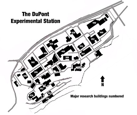
Experimental Station Map

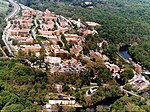
The DuPont Experimental Station is the main research and development site of DuPont and Chemours, located along Delaware Route 141. The site map is shown in the Figure and the buildings are numbered. The map is not fixed in time in that not all of the building shown existed in the same time frame. Some were demolished before other were built. The site was initiated along the banks of the Brandywine River so the lowest numbers are in the lower left of the map. Expansion has taken place toward the upper right, slowly displacing the DuPont Country Club, so those are the more modern buildings and the more recent history of the site. Each of the business units of the company have had research facilities at the Experimental Station, so the inventions listed below reflect the nature of the research carried out in each building.

Excerpt from the Wikipedia article List of DuPont Experimental Station inventions (License: CC BY-SA 3.0, Authors, Images).

List of DuPont Experimental Station inventions
H Road,

Geographical coordinates (GPS) Address Nearby Places
placeShow on map

Wikipedia: List of DuPont Experimental Station inventionsContinue reading on Wikipedia

Geographical coordinates (GPS)

Latitude Longitude
N 39.773888888889 ° E -75.571944444444 °
placeShow on map

Address

H Road

H Road
19806
Delaware, United States
mapOpen on Google Maps

Experimental Station Map
Share experience

Nearby Places

Breck's Mill Area
Breck's Mill Area

Breck's Mill Area, also known as Breck's Mill Area-Henry Clay Village Historic District, is a national historic district located along Brandywine Creek in unincorporated New Castle County, Delaware, near Wilmington. It encompasses 56 contributing buildings, five contributing sites, and three contributing structures. The district encompasses The Mill, The Workers' houses, and The Mill Owner's Home. Breck's Mill was built in 1813 and rebuilt in 1846 after a fire. It is a three-story, stone structure measuring 55 feet by 43 feet. It features a stone bell tower with a top floor of brick. The Henry Clay Village area includes small single or double workers' houses, the Charles I. du Pont house (1823), Ernest du Pont house (1916), William F. Raskob house , Hagee's Tavern, Greenhill Presbyterian Church, and the original building for the Alexis I. duPont High School (1893). "Rokeby" was built in 1836, and is a two-story, rectangular dwelling in a late Federal style. It measures 55 feet wide and 26 feet, 4 inches, deep, and features a two-story portico overlooking the Brandywine. It was built by mill owner William Breck for his new wife Gabrielle du Pont and is thought to be modeled on Louviers. The mill closed in 1854. It has been a recreational center off and on since 1890. Breck's Mill houses the post office for Montchanin, Delaware, Somerville Manning Gallery, and André Harvey's sculpture studio. It was added to the National Register of Historic Places in 1971 and amended in 1988.