Pei Ho Street

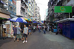
Pei Ho Street (Chinese: 北河街; Cantonese Yale: bak1 ho4 gaai1) is street in Sham Shui Po, New Kowloon, Hong Kong. The street is also a market and full of hawkers. The former Urban Council had built a Pei Ho Street Municipal Services Building (then known as Pei Ho Street Urban Council Complex) accommodating some stalls in the old market. Low economic profile and height limit of buildings on airway of former Kai Tak Airport helps Pei Ho Street to preserve buildings on the earliest planned town of Sham Shui Po in Western Kowloon. The style of Ke Lau (騎樓), balcony with two front pillars, once popular in colonial Hong Kong prior to World War II are easily found on the street. The end of the Pei Ho Street was the former Sham Shui Po Ferry Pier. The pier was an important ferry pier from 1920s to 1970s. Thousands of commuters took ferry to Central on the Hong Kong Island.
Excerpt from the Wikipedia article Pei Ho Street (License: CC BY-SA 3.0, Authors, Images).Pei Ho Street
Cheung Sha Wan Road, Kowloon Sham Shui Po (Sham Shui Po District)
Geographical coordinates (GPS) Address Nearby Places Show on map
 Continue reading on Wikipedia
 Geographical coordinates (GPS)
| Latitude | Longitude |
|---|---|
| N 22.33052 ° | E 114.16293 ° |
Address
深水埗 Sham Shui Po
Cheung Sha Wan Road
Kowloon, Sham Shui Po (Sham Shui Po District)
Hong Kong, China
Open on Google Maps