Pajottenland
Areas of BelgiumFlemish Brabant geography stubsGeography of Flemish BrabantRegions of Flanders
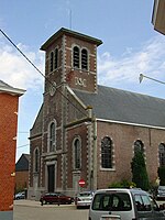
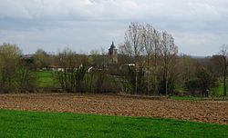
The Pajottenland (in English occasionally Payottenland) is a distinct region within the Flemish Brabant province and the south-western part of the Brussels Region of Belgium. The region is located west-southwest of Brussels. The Pajottenland is predominantly farmland, with occasional gently rolling hills, and lies mostly between the rivers Dender and Zenne / Senne. The area has historically provided food and drink for the citizens of Brussels, especially Lambic beers, which are only produced here and in the Zenne valley where Brussels is.
Excerpt from the Wikipedia article Pajottenland (License: CC BY-SA 3.0, Authors).Pajottenland
Vierthiendagwandweg,
Geographical coordinates (GPS) Address Nearby Places Show on map
Geographical coordinates (GPS)
| Latitude | Longitude |
|---|---|
| N 50.783333333333 ° | E 4.1166666666667 ° |
Address
Vierthiendagwandweg
Vierthiendagwandweg
1755
Flemish Brabant, Belgium
Open on Google Maps


