place

Politz Hebrew Academy

1915 establishments in PennsylvaniaColonial Revival architecture in PennsylvaniaJewish schools in the United StatesNortheast PhiladelphiaPhiladelphia County, Pennsylvania Registered Historic Place stubs
Religious schools in PennsylvaniaSchool buildings completed in 1915School buildings on the National Register of Historic Places in Philadelphia
Jacobs School Philly

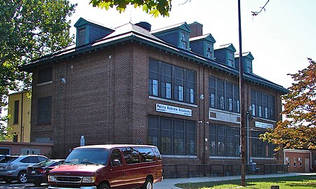
Politz Hebrew Academy, formerly known as William C. Jacobs School and Fayette School, is a historic school located in the Bustleton neighborhood of Philadelphia, Pennsylvania. The building consists of an original section designed by Samuel Sloan in 1855, and the main building built in 1915. The original building is a two-story, stone building sheathed in stucco. The 1915 building is a 2+1⁄2-story, three-bay, rectangular brick building in the Colonial Revival style. It features a hipped roof and gable dormers.The building was added to the National Register of Historic Places in 1988.

Excerpt from the Wikipedia article Politz Hebrew Academy (License: CC BY-SA 3.0, Authors, Images).

Politz Hebrew Academy
Old Bustleton Avenue, Philadelphia

Geographical coordinates (GPS) Address Phone number Website External links Nearby Places
placeShow on map

Wikipedia: Politz Hebrew AcademyContinue reading on Wikipedia

Geographical coordinates (GPS)

Latitude Longitude
N 40.0805 ° E -75.0391 °
placeShow on map

Address

Politz Hebrew Academy

Old Bustleton Avenue 9225
19115 Philadelphia
Pennsylvania, United States
mapOpen on Google Maps

Phone number

call(215)9695960

Website
politzhebrewacademy.org

linkVisit website

linkWikiData (Q5439025)
linkOpenStreetMap (357373963)

Jacobs School Philly
Share experience

Nearby Places

Bustleton, Philadelphia

The Bustleton section of Northeast Philadelphia is located in the Far Northeast, north of Rhawnhurst and Fox Chase and south of Somerton; sitting between Roosevelt Boulevard to the east, the city boundary to the west, Red Lion Road to the north, and Pennypack Park to the south, it is centered at the intersection of Grant Avenue and Bustleton Avenue (PA-532) and is completely included in the 19115 postal ZIP code. In the early history of the city, the neighborhood was centered on the Bustleton Tavern, a local bar established before the American Revolution. Pennypack Park is part of the Fairmount Park system and was the site of much industry including mills. The area was a trading center and had hotels drawing farmers bringing goods for sale via horse and buggy. Much of the commerce was also conducted via small streams and rivers of the present-day Pennypack Watershed. The old Paul's Run waterway once provided navigation from the Bustleton Tavern all the way to the Delaware River. Bustleton was originally part of Lower Dublin Township, also known as Dublin Township, a defunct township that was located in Philadelphia County, Pennsylvania. The township ceased to exist and was incorporated into the City of Philadelphia following the passage of the Act of Consolidation, 1854.Bustleton is home to the Lower Dublin Baptist Church, one of the oldest churches in America. Its burial ground contains the remains of many notable Americans and Revolutionary War Soldiers. Another church is the Protestant Episcopal Church of Saint Luke The Beloved Physician. It is the only church in Philadelphia that was designed by the architect Richard Upjohn of New York. It is located on Welsh Road and has a burial ground, now home to the veterans from the Civil War to present. It was consecrated on the 30th August 1861.The 1870 Roman Catholic Church of Maternity, Blessed Virgin Mary on Old Bustleton Ave in Pennypack Park is the large Roman Catholic parish that served as a mother church for most of the parishes in the Northeast section of Philadelphia. Saint Katherine Drexel attended Mass in the Old BVM Church.One of the early schools went by the name: Bustleton Academy, also known as The Academy at Bustelton, not to be confused with Lower Dublin Academy which is an older school, located in the Holmesburg section of Lower Dublin.

Ashton-Woodenbridge, Philadelphia

Ashton-Woodenbridge (also known as Ashton-Wooden Bridge and Pennypack) is a neighborhood in Northeast Philadelphia, in the U.S. state of Pennsylvania. It is located on the eastern side of the far northeast, in the vicinity of Northeast Philadelphia Airport, including Wooden Bridge Run west to Academy Gardens, and south to Pennypack Park. Originally farm land, it was part of the holdings of Thomas Holme, surveyor for Philadelphia's founder, William Penn. The area was part of one of the original townships, Lower Dublin Township, until the 1854 Act of Consolidation incorporated it into the City of Philadelphia. Holme emancipated his slaves upon his death, and their descendants owned much of the area. Remnants of their community can still be seen near present-day Holme Circle, where stood a village formerly called Harrisburg. Their tiny Bethany A.M.E. Church, located on Ashton Road, at least unofficially rivals Mother Bethel A.M.E. as the oldest African-American church. "Woodenbridge" is from Wooden Bridge Run, a creek that flows through the north of the area, a tributary of Pennypack Creek. The name "Ashton-Woodenbridge" first came into use in the 1970s [1] to honor the Ashton Family whose progenitor settled in the area in 1653 before William Penn. Joseph Ashton's Farm, River Dale, on the Delaware River, is now the Torresdale Filter Plant [2]. Other Ashtons settled up the Pennypack Creek in and around Ashton Road. Active farms dotted the area as late as the early 1960s and horse-drawn wagons frequently served as local transit during snowy weather, navigating the steep Ashton Road to take workers to the bus stop at Holme Circle. The area has long been served by freight railroad, and there remains active industry in the area. Crown, Cork, and Seal was a long-time anchor on Ashton Road, finally relocating their world headquarters north on a large campus. Northeast Philadelphia Airport lies at the north end of Ashton Road at Grant Avenue. Originally a World War II airbase, it now serves as a general-aviation reliever airport for Philadelphia International Airport. Despite having no scheduled passenger service, it is the sixth-busiest airport in Pennsylvania.The area was settled in earnest by veterans of World War II during the dramatic expansion of the Northeast. The housing stock is primarily twins, row homes, townhouses, and apartments.

Pennypack Park
Pennypack Park

Pennypack Park is a municipal park, part of the Philadelphia Parks & Recreation system, in Northeast Philadelphia in the U.S. state of Pennsylvania. Established in 1905 by ordinance of the City of Philadelphia, it includes about 1,600 acres (6 km2) of woodlands, meadows and wetlands. The Pennypack Creek runs through the park from Pine Road to the Delaware River. The park has playgrounds, hiking and bike trails, and bridle paths for horseback riding. An adjunct to the park is the Pennypack Environmental Center on Verree Road. More than 150 species of nesting and migrating birds use the park, including the tiny ruby-throated hummingbird, the great blue heron, warblers, the pileated woodpecker, several kinds of seabirds, ducks, geese, hawks, great horned owls and the little screech owl to name only a few. Famous for its large, scattered deer herd, the park is home to a large variety of mammals, including several kinds of bat, the red and gray fox, rabbits, chipmunks, mice, muskrats, groundhogs, raccoons, skunks, opossum and weasels. The park is home to many reptile species including several kinds of snakes, turtles (including common snapping turtles), frogs, the common toad and several kinds of salamanders. Many historic structures remain intact throughout Pennypack Park. Built in 1697, the King's Highway Bridge at Frankford Avenue is the oldest stone bridge still in use in the United States. Pennepack Baptist Church, another of the park's historic sites, was chartered in 1688. During the American Revolutionary War The Verree House on Verree Road was the site of a raid by British troops. The trained eye can rediscover abandoned railroad grades, remnants of early mills, mill races and other reminders that generations of mankind have gathered in the "Green Heart" of Northeast Philadelphia.