place

Touch House

Category A listed buildings in Stirling (council area)Inventory of Gardens and Designed LandscapesListed houses in Scotland

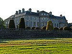
Touch House is a country house located 4 kilometres (2.5 mi) west of Stirling in central Scotland. It stands at the foot of the Touch Hills, on the south side of the River Forth. The house incorporates a 16th-century tower house, but its present form dates to the middle of the 18th century when the south facade was added, described by Historic Environment Scotland as "Probably the finest Georgian elevation in the County of Stirling."The house is a category A listed building, and the grounds are included in the Inventory of Gardens and Designed Landscapes in Scotland, the national listing of significant gardens.

Excerpt from the Wikipedia article Touch House (License: CC BY-SA 3.0, Authors).

Touch House
Touch Road, Stirling

Geographical coordinates (GPS) Address Nearby Places
placeShow on map

Wikipedia: Touch HouseContinue reading on Wikipedia

Geographical coordinates (GPS)

Latitude Longitude
N 56.1111 ° E -4.0062 °
placeShow on map

Address

Touch Business Centre

Touch Road
FK8 3AG Stirling
Scotland, United Kingdom
mapOpen on Google Maps

Share experience

Nearby Places

Allan Water
Allan Water

The Allan Water (Scottish Gaelic: Uisge Alain) is a river in central Scotland. Rising in the Ochil Hills, it runs through Strathallan to Dunblane and Bridge of Allan before joining the River Forth. It is liable to cause floods in lower Bridge of Allan.It shares its name with a tributary of the River Teviot. The name is similar to the Ale Water in Berwickshire, the River Alness in Ross-shire, the Allander Water in Stirlingshire, the River Alne and the Ayle Burn in Northumberland, the River Ellen in Cumbria, and several names in the south of England, Wales and Cornwall. Ptolemy, who wrote his Geography about 150 AD, gave the names of some of these rivers as Alauna or Alaunos. Ekwall says that Alauna or Alaunos are British [i.e. Brythonic or P-Celtic] river names. Nicolaisen says that the name Allan is of Pre-Celtic Indo-European origin. Its original form was Alauna, from the Indo-European root *el-/ol-, meaning "to flow, to stream". Several European rivers and settlements have names that may come from that root. Others say that Alauna was a Celtic river goddess, also found in Brittany; Alaunus was a Gaulish god of medicine and prophesy. Two broadside ballads refer to the "Allan Water". According to one, a Scottish ballad, the "Allan Water's wide and deep, and my dear Anny's very bonny; Wides the Straith that lyes above't, if't were mine I'de give it all for Anny." The other, more familiar, English ballad begins "On the banks of Allan Water" and relates the death of a miller's daughter whose soldier lover proves untrue. This version, popularised by C. E. Horn in his comic opera, Rich and Poor (1812), is sung by Bathsheba Everdene at the sheepshearing supper in Thomas Hardy's novel Far From The Madding Crowd (1874). A similar rendition was recorded with church organ accompaniment by Italian singer Ariella Uliano in 2008.

Stirling Sill

The Stirling Sill is an outcropping of a large quartz-dolerite intrusion or sill that underlies a large part of central Scotland, and may be contiguous at great depth. The sill is of very late Carboniferous age or more probably Permian, as it penetrates the coal measures, often in bedding planes between the various strata. In places, it rises through fractures in the strata to a new level, forming features that, at the surface, would be called dikes. At its outcrop on the west, the sill generally lies towards the base of the Carboniferous sequence, and just above the calciferous sandstone deposits and lavas, as can be seen in the upper part of the valley of the Bannock Burn. However, to the consternation of miners, it occupies a higher position amongst the useful strata towards the east, and in places has destroyed the coal, while in others the effect of the sill has been to convert the coal to more valuable anthracite. The slope of the Abbey Craig, or the Stirling Castle rock, gives a general idea of the angle of dip of the coal measures at the extremity or the coalfield, and the thickness of the sill can also be seen, which is approximately 100 metres.Geologists have had various theories about the formation of anthracite, as the coal has been most effectively baked near the Ochil Fault, however the theories are not necessarily incompatible.The source of the sill, where the molten rock rose from below, is not known; however it is known that there are risers in the Ochil Fault, although these are inconsistent with the overall structure. The main origin of the sill may be in the region of the eruptive centre that formed the Ochil Hills in a much earlier period, which geologists postulate is somewhere to the east of Stirling, possibly in the region of Kincardine. This ties in with subsidence following the first round of eruptive activity that lead to the formation of the coal basins, with a much later outbreak of intrusive activity from the same magma feeders, however the truth will remain unknown because it would take very many deep bores in hard rock to probe the depths and find the necessary evidence.The western extremities of the sill can be seen at the Abbey Craig, Stirling Castle, Kings Park, Gillies Hill, Sauchieburn and various points to the south. The quartz-dolerite was once quarried at several places including Cambusbarron and Murrayshall, but is quarried today at Northfield, primarily for roadstone.