place

Lecropt

Former civil parishes of ScotlandLecroptPopulated places in Stirling (council area)
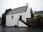
Lecropt Kirk geograph.org.uk 1230943

Lecropt (Leac Croit in Gaelic) is a rural parish lying to the west of Bridge of Allan, Scotland. The population of the parish of Lecropt is estimated to be around 75, consisting entirely of isolated farms and houses, as well as the Keir Estate owned by the landed Stirling family. Lecropt today contains no town or village, though it lies on the outskirts of the village of Bridge of Allan. Historically, Lecropt's population was higher and was as high as 500 around the year 1800. The decline in population over the decades can be explained partly, but not wholly, by rural depopulation. However, in 1800 Bridge of Allan, then a tiny hamlet of no more than 100 people, was included in Lecropt. As Bridge of Allan grew during the 19th century, the whole village was eventually brought under the adjacent parish of Logie, reducing Lecropt's population. There had also been another village called Lecropt, the site of which was further north-west, on the other side of the line of the M9 motorway from the current parish church. This village hosted the parish church until this was moved to its present site in the early 19th century, on the A9 road. The village of Lecropt itself had been abandoned.

Excerpt from the Wikipedia article Lecropt (License: CC BY-SA 3.0, Authors, Images).

Lecropt
Stirling Inverallan

Geographical coordinates (GPS) Address Nearby Places
placeShow on map

Wikipedia: LecroptContinue reading on Wikipedia

Geographical coordinates (GPS)

Latitude Longitude
N 56.157 ° E -3.98 °
placeShow on map

Address


FK9 4PW Stirling, Inverallan
Scotland, United Kingdom
mapOpen on Google Maps

Lecropt Kirk geograph.org.uk 1230943
Share experience

Nearby Places

Allan Water
Allan Water

The Allan Water (Scottish Gaelic: Uisge Alain) is a river in central Scotland. Rising in the Ochil Hills, it runs through Strathallan to Dunblane and Bridge of Allan before joining the River Forth. It is liable to cause floods in lower Bridge of Allan.It shares its name with a tributary of the River Teviot. The name is similar to the Ale Water in Berwickshire, the River Alness in Ross-shire, the Allander Water in Stirlingshire, the River Alne and the Ayle Burn in Northumberland, the River Ellen in Cumbria, and several names in the south of England, Wales and Cornwall. Ptolemy, who wrote his Geography about 150 AD, gave the names of some of these rivers as Alauna or Alaunos. Ekwall says that Alauna or Alaunos are British [i.e. Brythonic or P-Celtic] river names. Nicolaisen says that the name Allan is of Pre-Celtic Indo-European origin. Its original form was Alauna, from the Indo-European root *el-/ol-, meaning "to flow, to stream". Several European rivers and settlements have names that may come from that root. Others say that Alauna was a Celtic river goddess, also found in Brittany; Alaunus was a Gaulish god of medicine and prophesy. Two broadside ballads refer to the "Allan Water". According to one, a Scottish ballad, the "Allan Water's wide and deep, and my dear Anny's very bonny; Wides the Straith that lyes above't, if't were mine I'de give it all for Anny." The other, more familiar, English ballad begins "On the banks of Allan Water" and relates the death of a miller's daughter whose soldier lover proves untrue. This version, popularised by C. E. Horn in his comic opera, Rich and Poor (1812), is sung by Bathsheba Everdene at the sheepshearing supper in Thomas Hardy's novel Far From The Madding Crowd (1874). A similar rendition was recorded with church organ accompaniment by Italian singer Ariella Uliano in 2008.