place

Holtby

Civil parishes in North YorkshireOpenDomesdayUse British English from May 2017Villages in the City of York
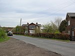
Holtby Church geograph.org.uk 2372466

Holtby is a small village and civil parish in the unitary authority of the City of York in North Yorkshire, England. The population at the 2011 Census was 166. It lies close to the A166 about 5 miles (8 km) east of York.

Excerpt from the Wikipedia article Holtby (License: CC BY-SA 3.0, Authors, Images).

Geographical coordinates (GPS)

Latitude Longitude
N 53.97945 ° E -0.9728 °
placeShow on map

Address

Holtby Lane

Holtby Lane
YO19 5UE
England, United Kingdom
mapOpen on Google Maps

Holtby Church geograph.org.uk 2372466
Share experience

Nearby Places

St Nicholas' Church, Dunnington

St Nicholas' Church, Dunnington is a Grade II* listed parish church in Dunnington, a village in the rural south-eastern part of the City of York, in England. The oldest fragments of the church date from the 11th century, with the two-bay nave and lower part of the tower being 12th century. North and south aisles, since replaced, were also added. In the 13th century, the east end of the church was rebuilt as a three-bay chancel is 13th century, with the original piscina and sedilia surviving inside, along with two brackets which now support 19th century sculptures. The upper part of the tower dates from the 15th century. The church is built of a mixture of limestone, sandstone and millstone grit. The church was restored in 1717 and between 1738 and 1740, when the pulpit was replaced. The building was then partly rebuilt between 1839 and 1841, when the aisles were reconstructed, and a north porch was added, becoming the main entrance. The next reconstruction was in 1877, this later work being by C. Hodgson Fowler. In 1930, the north aisle of the chancel was converted into a chapel. Finally, in 1987, a church hall was added.The church's stained glass is 19th and later. The east window, designed by William Wailes, dated from about 1840, but was replaced in 2009 by new glass, designed by Helen Whittaker. In the churchyard are the remains of a stone cross - its base and part of its shaft - which may date from the 14th century.

Danelaw
Danelaw

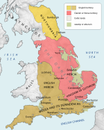
The Danelaw (, also known as the Danelagh; Old English: Dena lagu; Danish: Danelagen) was the part of England in which the laws of the Danes held sway and dominated those of the Anglo-Saxons. The Danelaw contrasts with the West Saxon law and the Mercian law. The term is first recorded in the early 11th century as Dena lage. The areas that constituted the Danelaw lie in northern and eastern England, long occupied by Danes and other Norsemen. The Danelaw originated from the invasion of the Great Heathen Army into England in 865, but the term was not used to describe a geographic area until the 11th century. With the increase in population and productivity in Scandinavia, Viking warriors, having sought treasure and glory in the nearby British Isles, "proceeded to plough and support themselves", in the words of the Anglo-Saxon Chronicle for 876.Danelaw can describe the set of legal terms and definitions created in the treaties between Alfred the Great, the king of Wessex, and Guthrum, the Danish warlord, written following Guthrum's defeat at the Battle of Edington in 878. In 886, the Treaty of Alfred and Guthrum was formalised, defining the boundaries of their kingdoms, with provisions for peaceful relations between the English and the Vikings. The language spoken in England was affected by this clash of cultures, with the emergence of Anglo-Norse dialects.The Danelaw roughly comprised these contemporary 15 shires: Leicester, York, Nottingham, Derby, Lincoln, Essex, Cambridge, Suffolk, Norfolk, Northampton, Huntingdon, Bedford, Hertford, Middlesex, and Buckingham.