Danelaw

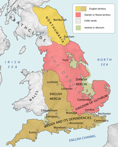
The Danelaw (, also known as the Danelagh; Old English: Dena lagu; Danish: Danelagen) was the part of England in which the laws of the Danes held sway and dominated those of the Anglo-Saxons. The Danelaw contrasts with the West Saxon law and the Mercian law. The term is first recorded in the early 11th century as Dena lage. The areas that constituted the Danelaw lie in northern and eastern England, long occupied by Danes and other Norsemen. The Danelaw originated from the invasion of the Great Heathen Army into England in 865, but the term was not used to describe a geographic area until the 11th century. With the increase in population and productivity in Scandinavia, Viking warriors, having sought treasure and glory in the nearby British Isles, "proceeded to plough and support themselves", in the words of the Anglo-Saxon Chronicle for 876.Danelaw can describe the set of legal terms and definitions created in the treaties between Alfred the Great, the king of Wessex, and Guthrum, the Danish warlord, written following Guthrum's defeat at the Battle of Edington in 878. In 886, the Treaty of Alfred and Guthrum was formalised, defining the boundaries of their kingdoms, with provisions for peaceful relations between the English and the Vikings. The language spoken in England was affected by this clash of cultures, with the emergence of Anglo-Norse dialects.The Danelaw roughly comprised these contemporary 15 shires: Leicester, York, Nottingham, Derby, Lincoln, Essex, Cambridge, Suffolk, Norfolk, Northampton, Huntingdon, Bedford, Hertford, Middlesex, and Buckingham.
Excerpt from the Wikipedia article Danelaw (License: CC BY-SA 3.0, Authors, Images).Danelaw
The Village,
Geographical coordinates (GPS) Address Phone number Website Nearby Places Show on map
Geographical coordinates (GPS)
| Latitude | Longitude |
|---|---|
| N 54 ° | E -1 ° |
Address
Stockton-on-the-Forest Primary School
The Village
YO32 9UP
England, United Kingdom
Open on Google Maps


