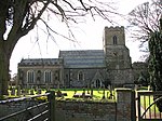
Wimbotsham

Wimbotsham is a village and civil parish in the English county of Norfolk. It is situated close to the River Great Ouse, 2 km (1.2 mi) north of the town of Downham Market, 18 km (11 mi) south of the town of King's Lynn, and 60 km (37 mi) west of the city of Norwich. It covers an area of 6.04 km2 (2.33 sq mi) and had a population of 558 in 262 households at the 2001 census, the population including Bexwell and increasing to 664 at the 2011 Census. For the purposes of local government, it falls within the district of King's Lynn and West Norfolk. The villages name means 'Winebaud's homestead/village' or 'Winebaud's hemmed-in land'. It has a primary school, a local shop and a public house called "The Chequers". Also located in the village are two churches: the Church of St Mary and the Wimbotsham Methodist Church.
Excerpt from the Wikipedia article Wimbotsham (License: CC BY-SA 3.0, Authors, Images).Wimbotsham
Broomhill, King's Lynn and West Norfolk Wimbotsham
Geographical coordinates (GPS) Address Nearby Places Show on map
Geographical coordinates (GPS)
| Latitude | Longitude |
|---|---|
| N 52.61765 ° | E 0.39448 ° |
Address
Broomhill
PE34 3QL King's Lynn and West Norfolk, Wimbotsham
England, United Kingdom
Open on Google Maps


