place

Amman (Spokane, Washington)

Buildings and structures completed in 1904Buildings and structures in Spokane, WashingtonNational Register of Historic Places in Spokane, WashingtonResidential buildings on the National Register of Historic Places in Washington (state)Wikipedia page with obscure subdivision
Amman Building NRHP 87000086 Spokane County, WA

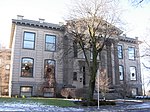
Amman or Ammann, in the Browne's Addition neighborhood of Spokane, Washington is a building constructed in 1904. It was designed by architect Albert Held. The building was listed on the U.S. National Register of Historic Places in 1987. Although the National Register of Historic Places list the property under the name Amman the Spokane Register of Historic Places lists the building as Ammann.As of 2022, the building is known as The Dormitory and home to a mix of retail and office space surrounding the central common area on the first and second stories. Retail on the first floor, as of 2022 includes a coffee shop and roaster, and a bakery and cheese shop.

Excerpt from the Wikipedia article Amman (Spokane, Washington) (License: CC BY-SA 3.0, Authors, Images).

Amman (Spokane, Washington)
West Riverside Avenue, Spokane

Geographical coordinates (GPS) Address Nearby Places
placeShow on map

Wikipedia: Amman (Spokane, Washington)Continue reading on Wikipedia

Geographical coordinates (GPS)

Latitude Longitude
N 47.656638888889 ° E -117.43475 °
placeShow on map

Address

West Riverside Avenue 1516
99201 Spokane
Washington, United States
mapOpen on Google Maps

Amman Building NRHP 87000086 Spokane County, WA
Share experience

Nearby Places

Peaceful Valley Historic District

The Peaceful Valley Historic District is a National Register of Historic Places-listed historic district in the Peaceful Valley neighborhood of Spokane, Washington. It is located in the western half of the neighborhood, along the floor and southern slope of the Spokane River Gorge, immediately south of the Spokane River and downhill, just below Downtown Spokane. It is centered on the intersection of Main Avenue and Maple Street, stretching from there approximately two blocks in each direction. A residential area, Peaceful Valley was one of the first areas developed in the City of Spokane and was deemed historically significant as an intact example of a working-class neighborhood from the turn of the 20th century. Unlike many other historic districts around the city and state, Peaceful Valley does not represent the moneyed-elite whose grand homes and buildings have been preserved but rather homes of the working class laborers who helped built Spokane throughout its early decades. Located in a steep valley just downstream of Spokane Falls and immediately below the city center which lies on the flat land at the top of the valley to the south and east. This location, isolated by the river and deep gorge, have helped preserve Peaceful Valley's architectural character into the 21st cenutry, though some construction projects such as the Maple Street Bridge which was constructed over the area in the late 1950s have slightly altered the appearance in places, though not the overall cohesion, of the district.

West Downtown Historic Transportation Corridor

The West Downtown Historic Transportation Corridor is a historic commercial district in Spokane, Washington located, as the name suggests, in the western portion of the city's downtown neighborhood. The district, which was listed on the National Register of Historic Places (NRHP) in 1999, consists mostly of buildings constructed between the late 19th century and 1949. It contained at the time of listing 65 buildings or structures, 50 of which are considered contributing properties to the district. Seven properties in the district are listed on the NRHP individually as well.It draws its name from its location along the Union Pacific and BNSF Railways and former route of U.S. Route 10, which ran along First Avenue one block north of the railroad grade. The district was constructed to serve the transportation industry of the railroad and later of the highway as well. Buildings in the district served purposes that originally fell into one of three categories: lodging for travelers, automotive service stations and showrooms, or railroad-dependent warehouses. Most of the buildings are constructed of red brick or reinforced masonry. Prior to the construction of Interstate 90 in the 1960s, most travelers passing through Spokane were funneled through the district. In the decades after the arrival of the interstate, with much of its original purpose no longer in place, the district fell into decline and became a center for blight and crime in the city center. Starting in the late-1990s and continuing into the 2020s, the area has seen considerable investment and revitalization. It is now a vibrant part of the city center, home to numerous boutiques, restaurants, breweries and residences. While the district has largely moved on from its original transport-dependent industries, with the exception of a few hotels which still operate in the area, the visual integrity of the district remains mostly intact.