Wretton
Civil parishes in NorfolkKing's Lynn and West NorfolkNorfolk geography stubsVillages in Norfolk

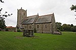
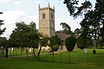
Wretton is a village and civil parish in the English county of Norfolk. It covers an area of 4.7 km2 (1.8 sq mi) and had a population of 392 in 155 households at the 2001 census. For the purposes of local government, it falls within the district of King's Lynn and West Norfolk. The villages name means "Crosswort/hellebore farm/settlement". It is situated 4 miles (6.4 km) east of Downham Market, 16 miles (26 km) south of King's Lynn and 40 miles (64 km) west of Norwich. Also 1.5 miles (2.4 km) North of the larger village of Stoke Ferry.
Excerpt from the Wikipedia article Wretton (License: CC BY-SA 3.0, Authors, Images).Wretton
Field Lane, King's Lynn and West Norfolk Wretton
Geographical coordinates (GPS) Address Nearby Places Show on map
Geographical coordinates (GPS)
| Latitude | Longitude |
|---|---|
| N 52.5723 ° | E 0.4925 ° |
Address
Field Lane
Field Lane
PE33 9QT King's Lynn and West Norfolk, Wretton
England, United Kingdom
Open on Google Maps


