place

Lakeside, Cumbria

Colton, CumbriaCumbria geography stubsUse British English from September 2019Villages in Cumbria
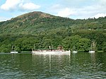
Teal at Lakeside geograph.org.uk 311514

Lakeside is a village in Newby Bridge at the south end of Windermere, England. Now in the county of Cumbria, before county reorganisation of 1974 it was in Lancashire, as part of the region known as Furness. It was established as a steamer pier for services along the lake when the Lakeside branch of the Furness Railway reached it in 1869, meaning that steamer services no longer had to negotiate the River Leven to Newby Bridge. Also built at Lakeside was a hotel to serve the tourists brought by the railway and steamers. The steamers still call at Lakeside and the railway is now a steam-hauled heritage railway, operated as the Lakeside & Haverthwaite Railway. However, it now only operates as far as Haverthwaite, with the route beyond to Ulverston closed in 1965 as part of the Beeching cuts. It now contains the Aquarium of the Lakes, an aquarium featuring fish found in the rivers and seas around the Lake District. In November 2009, the village including Lakeside Hotel and the Lakes Aquarium was partially flooded. The floods resulted in the closure of both businesses until early 2010 as well as the sinking of moored yachts and severe road blockages.

Excerpt from the Wikipedia article Lakeside, Cumbria (License: CC BY-SA 3.0, Authors, Images).

Geographical coordinates (GPS)

Latitude Longitude
N 54.278 ° E -2.957 °
placeShow on map

Address


LA12 8AP , Colton
England, United Kingdom
mapOpen on Google Maps

Teal at Lakeside geograph.org.uk 311514
Share experience

Nearby Places

Gummer's How
Gummer's How

Gummer's How is a hill in the southern part of the Lake District, on the eastern shore of Windermere, near its southern end. How, derived from the Old Norse word haugr, is a common local term for a hill or mound. Although a relatively small hill (321 metres above sea level) by the standards of the Lake District, it is the highest of the foothills in the area and commands excellent views, particularly along Windermere (the summit looks out over the magnificent Town Head House estate towards the lake), but also across to the Coniston fells and the central fells, as well as the broad panorama of Morecambe Bay. There is an OS trig point on the summit. The walk to the summit is usually from the road at Astley's Plantation car park, itself at over 200 metres above sea level, and only 700 metres from the summit. Although short and easy by most standards, and popular with families, it has many of the characteristics of a walk in the higher Lakeland fells, with some (short) steep slopes, rocks to negotiate, and rowan, bracken and heather. The lower slopes are forested, but the upper portion is moorland.Gummer's How is the subject of a chapter of Wainwright's book The Outlying Fells of Lakeland. He describes it as "an old man's mountain", and says of it: "And when ancient legs can no longer climb it know ye that the sad day has come to hung up the boots for ever and take to slippers".Simon Jenkins rates the Windermere panorama of the Lake District, Pennines and Morecambe Bay as one of the top ten in England.