place

Ocean Gateway Pier II

2010 establishments in MaineBuildings and structures completed in 2010Transportation buildings and structures in Portland, Maine

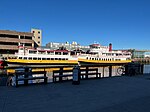
Ocean Gateway Pier II is a floating deepwater cruise ship pier located at the Ocean Gateway International Marine Passenger Terminal in Portland, Maine. Construction of the pier began on 1 November 2010 with a groundbreaking ceremony attended by Maine governor John Baldacci and city officials. It was opened on 10 September 2011, when Enchantment of the Seas became the first vessel to dock at the pier.The total cost of building the pier was about $6 million, paid for by a state transportation bond. It was built by the Reed & Reed construction company, which submitted a bid about $1.5 million less than had been budgeted for, allowing an extension of the pier by about 100 feet (30 m) over the original plan and the addition of water and electrical services.The pier is composed of a 124-foot (38 m) floating barge, anchored to the seabed, at the center of the structure for embarking passengers onto ships, with the remainder a gangway wide enough to accommodate vehicles the size of a golf cart. The gangway is supported by individual pilings and clusters of three pilings. The pier is able to accommodate ships as large as 1,200 feet (370 m) long.

Excerpt from the Wikipedia article Ocean Gateway Pier II (License: CC BY-SA 3.0, Authors).

Ocean Gateway Pier II
Ocean Gateway Pier, Portland

Geographical coordinates (GPS) Address Nearby Places
placeShow on map

Wikipedia: Ocean Gateway Pier IIContinue reading on Wikipedia

Geographical coordinates (GPS)

Latitude Longitude
N 43.6596 ° E -70.2432 °
placeShow on map

Address

Ocean Gateway Pier

Ocean Gateway Pier
04101 Portland
Maine, United States
mapOpen on Google Maps

Share experience

Nearby Places

Ocean Gateway International Marine Passenger Terminal

The Ocean Gateway International Marine Passenger Terminal is a cruise ship terminal in Portland, Maine, USA. It was built in two phases; phase 1 being a new terminal building that in 2008 replaced the original International Marine Terminal and phase 2 being a new berth and docking facility for large cruise ships known as Ocean Gateway Pier II. Plans for the new passenger terminal were made as early as 2003, when the Portland city council presented an early design for the facility, including two buildings — a 5,000-square-foot (460 m2) receiving building and a 16,000 square foot terminal building — built at the end of a pier. Construction began in September 2005, after the Reed and Reed construction company won the contract in June.The main terminal building is built over the water, and is a two-story structure, with customs facilities for international passengers on the first floor and a waiting area on the second. The terminal building is connected to the receiving building, located about 300 feet (90 m) away on shore, by a pair of pedestrian ramps. In addition to the receiving building, shore facilities include a 3.5-acre (1.4 ha) parcel of land for parking cars and boarding buses, both local and tour.Building the terminal facility cost about $20.5 million, of which $9 million came from a bond issue by the state of Maine, $6 million from the federal government and the remainder from a mix of local, state and federal sources.The building was formally opened on 2 May 2008 in a ceremony attended by about 200 people. Commercial shipping traffic began calling at the facility on 30 May, when HSC The Cat, operated by Bay Ferries, began its seasonal service to Yarmouth, Nova Scotia.Ocean Gateway is also used as rental venue for functions such as weddings, conventions and other public events, a use which grew in importance after The Cat service was canceled following the 2009 season, which meant a loss to the city of Portland of $150,000 per year in rent which Bay Ferries paid for use of the facility. The city estimates that rentals currently bring in about $90,000 a year since the ferry service ended.The second phase of the terminal project is Ocean Gateway Pier II, a deep-water pier for large cruise ships that opened in September 2011, allowing more and larger cruise ships to dock in the city.

Fort Loyal
Fort Loyal

Fort Loyal was a British settler refuge and colonial outpost built in 1678 at Falmouth (present-day Portland, Maine) in Casco Bay. It was destroyed in 1690 by Abenaki and French forces at the Battle of Fort Loyal. The fort was rebuilt in 1742 and renamed Falmouth Fort before King George's War and rearmed again in 1755 for the French and Indian War. The fort was rebuilt a final time in 1775 for the American Revolution. The peninsula was first colonized by the English in 1632 as a fishing and trading village named Casco. When the Massachusetts Bay Colony absorbed the Province of Maine in 1658, the town's name changed to Falmouth. In 1676, the village was destroyed by the Abenaki during King Philip's War. English colonists returned two years later when peace resumed. Fort Loyal was built in 1678 in the center of Portland at the foot of present-day India Street to protect the town from future attacks. In 1690 Fort Loyal consisted of four wooden blockhouses and eight guns. During King William's War, a raiding party of French and Native allies destroyed the English settlement and massacred its inhabitants in the Battle of Fort Loyal (1690). At the end of the conflict Massachusetts did not rebuild the fort, instead building Fort Casco in Falmouth. The fort was rebuilt in 1742 and renamed "Falmouth Fort" before King George's War and then rearmed during the French and Indian War in 1755. Reverend Thomas Smith described the 1759 celebration at the fort in Falmouth upon the arrival of news that Quebec had fallen: "The cannon were fired at the fort yesterday and today. Mr. Mayhew's house was illuminated, and small arms fired in the evening, upon further and more authentic news of the victory at Quebec." Earthworks were constructed on the Fort Loyal site in 1775 as part of harbor defenses during the American Revolution and known as the "Lower Battery." Elements from earlier iterations of the fort, such as the guard house, were still in use. The bluff on which the fort had been located was leveled off during the construction of the Grand Trunk Railway in the 1850s. Today the fort's location is memorialized by a plaque on the Grand Trunk Office Building at the corner of India and Thames Streets in Portland.

Portland station (Grand Trunk)

Portland station was a passenger rail station on the Grand Trunk Railway in Portland, Maine, United States. It stood to at the foot of India Street, Portland's first street, between 1903 and 1966. It was one of Portland's four railroad stations for the Portland and Forest Avenue Railroad Company over its history, and one of the two stations in the city at the time of the station's construction. The other was Union Station, which has also been demolished. The Grand Trunk and steamship offices building still stands, at the corner of India Street and Thames Street. As of 2024, it was in use as the head office of Gorham Savings Bank. A third story was added to this building in 1903. The station's clock tower was removed in 1948, eighteen years before the station itself was razed. Construction of the Grand Trunk Railways was delayed by the American Civil War, but used rail was obtained from New Brunswick in 1863 to complete a line from India Street along Middle Street, through Monument Square, along Congress Street, and then down High Street, and westerly along Spring Street to Clark Street. Service with horse-drawn street cars began on 12 October 1863. In 1864, an adjoining line was built along Preble Street from Monument Square and thence along Portland Street and Forest Avenue to Woodfords Corner. This line was later extended to Morrills Corner along Pleasant Avenue and Stevens Avenue. Lines along Congress Street were extended westward to Longfellow Square and eastward to Atlantic Street on Munjoy Hill. Horse-drawn sleighs were substituted for rail cars when snow and ice covered the streets during winter months to avoid ice removal inconveniencing other horse-drawn sleighs. In the late 19th century, Portland was favored over Boston as the seaport terminus for the Grand Trunk Railway from Montreal. When the Maine Coast Special train to Montreal was withdrawn 1966, the station was abandoned.

Fort Allen Park

Fort Allen Park is an urban park in the Munjoy Hill neighborhood of Portland, Maine, United States. It covers 9 acres (3.6 ha) and abuts the Eastern Promenade to the south. It was built in the 1890s, designed by the city's chief engineer William Goodwin and backed by mayor James P. Baxter, according to a plaque in the park. Fort Allen was probably originally built in 1775, may have served as part of Fort Sumner, and was rebuilt by the city and used to guard Portland during the War of 1812 due to its high vantage point overlooking Casco Bay. The park is home to a 6-inch gun from the USS Maine (the ship whose explosion in Havana, Cuba started the Spanish–American War), the foremast and bridge structure of the World War II cruiser USS Portland (CA-33), two Civil War-era 4.5-inch siege rifles, an American Civil War memorial bench erected in 1929, and an historic bandstand which was built in the 1890s. In 2012, a local non-profit group, Friends of the Eastern Promenade, sought to restore Fort Allen Park to its original look. As of 2016 this has resulted in additional interpretive plaques throughout the park, along with other improvements. Some sources state that Fort Allen dates from 1775 and was originally named for Revolutionary War hero Ethan Allen. It was initially a half-moon battery mounting five guns. After 1794 it may have served as the "detached battery" of nearby Fort Sumner, as described in the Secretary of War's report for 1811. Fort Allen was rebuilt in 1814 with city resources, adding a magazine and barracks due to the British capture of Eastport and Castine in the War of 1812. A plaque at the park states that at this time it was named for Master Commandant William Henry Allen, a naval officer mortally wounded in the War of 1812.