place

Chicora Wood Plantation

Greek Revival houses in South CarolinaHistoric American Buildings Survey in South CarolinaHistoric district contributing properties in South CarolinaHouses completed in 1819Houses in Georgetown County, South Carolina
Houses on the National Register of Historic Places in South CarolinaNRHP infobox with nocatNational Register of Historic Places in Georgetown County, South CarolinaPee Dee South Carolina Registered Historic Place stubsPlantation houses in South CarolinaPlantations in South CarolinaRice plantations in the United StatesUse mdy dates from August 2023
Chicora Wood Plantation, County Road No. 52 (north side), Georgetown vicinity (Georgetown County, South Carolina)

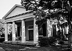
The Chicora Wood Plantation (originally known as Matanzas) is a former rice plantation in Georgetown County, South Carolina. The plantation itself was established sometime between 1732 and 1736 and the 1819 plantation house still exists today. In 1827, Robert Francis Withers Allston (1801–1864) resigned as surveyor-general of South Carolina to take over full-time management of Chicora Wood, which he had inherited from his father. Chicora Wood served as a home base for his network of rice plantations, which produced 840,000 pounds of rice in 1850 and 1,500,000 pounds by 1860. 401 slaves worked the plantation in 1850, increasing to 630 by 1860. The house was built in Greek Revival style, on a raised basement typical of the region. A number of outbuildings still survive on the complex, including the rice mill complex. It was listed in the National Register of Historic Places on April 11, 1973. It is located in the Pee Dee River Rice Planters Historic District.

Excerpt from the Wikipedia article Chicora Wood Plantation (License: CC BY-SA 3.0, Authors, Images).

Chicora Wood Plantation
Chicora Wood Avenue,

Geographical coordinates (GPS) Address Nearby Places
placeShow on map

Wikipedia: Chicora Wood PlantationContinue reading on Wikipedia

Geographical coordinates (GPS)

Latitude Longitude
N 33.5175 ° E -79.175555555556 °
placeShow on map

Address

Chicora Wood Avenue

Chicora Wood Avenue

South Carolina, United States
mapOpen on Google Maps

Chicora Wood Plantation, County Road No. 52 (north side), Georgetown vicinity (Georgetown County, South Carolina)
Share experience

Nearby Places

Sandy Island, South Carolina

Sandy Island is the name of a small unincorporated community in Georgetown County, South Carolina, United States, and a larger island between the Pee Dee and Waccamaw Rivers that has been preserved as a refuge and nature center. The island is about 9,000 acres (36 km2) of a prehistoric sand dune. It is bounded east and west by the rivers, on the north by Bull Creek, and on the south by Thoroughfare Creek. The northern part of the island is higher and is mostly a longleaf pine forest, which provides a refuge for the endangered red-cockaded woodpecker and numerous other species of plants and animals. About 9,000 acres (36 km2) of the island has been purchased by The Nature Conservancy for permanent protection from development. On the southern, lower end of the island are the remnants of old rice plantations, with the watergates and earthwork canals, built by African enslaved people who were skilled in rice culture. Such development was used to manage the water supply for irrigating the rice fields. A small community in the south is made up of a few families who are descendants of former slaves. The island is only accessible by boat, and workers and school children commute to the mainland daily for work and school. Because of its resources, the island is regularly visited by naturalists, planters, archaeologists and geologists. Brookgreen Gardens runs daily "scenic" boat rides close to the island. Tours of the southern end are available by private tour company.

All Saints Church (Pawleys Island, South Carolina)

All Saints Church Pawleys Island is a historic church complex and national historic district located on Pawleys Island, Georgetown County, South Carolina. The district encompasses three contributing buildings and one contributing site—the sanctuary, cemetery, rectory, and chapel. In 2004, it left the Episcopal Church to join the Diocese of the Carolinas, now part of the Anglican Church in North America, a denomination within the Anglican realignment movement. The sanctuary, built 1916–1917, the fourth to serve this congregation, is significant as an excellent example of the Classical Revival style, adapting the design of the church's 19th century sanctuary which burned in 1915. It is a one-story rectangular brick building sheathed in scored stucco. It has an engaged pedimented portico supported by four fluted Greek Doric order columns. A Doric frieze, composed of triglyphs, metopes, and guttae, runs under the cornice around the building on three sides. The church has a large center aisle sanctuary with a coved tray ceiling. The church cemetery, established in the 1820s, is significant for the persons buried there, many of whom were the leading public figures of antebellum Georgetown County. It is also significant a collection of outstanding gravestone art from about 1820 to 1900. The church rectory, built in 1822, is an intact example of a Carolina I-house. Its first congregation was formed in 1739, and the church has been located at this site since then. Associated with the church is the separately listed Cedar Grove Plantation Chapel.It was added to the National Register of Historic Places in 1991.