Gisborne, Victoria

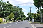
Gisborne () is a town in the Macedon Ranges, located about 54 kilometres (34 mi) north-west of Melbourne, Victoria, Australia. It is the largest town in the Macedon Ranges Shire, with a population of 14,432 as of June 2021 in the Gisborne district region.Gisborne is known for its country homesteads, tree-lined streets, restaurants and cafes. The town has become a popular 'tree change' destination for Melbourne residents seeking large leafy blocks and a quiet lifestyle within easy commuting distance from the city. As such, the town has grown substantially over the past 5–10 years, with an increase of almost 2,600 residents since 2011, although planning controls have been implemented to protect the character and "outstanding natural beauty" of the region.
Excerpt from the Wikipedia article Gisborne, Victoria (License: CC BY-SA 3.0, Authors, Images).Gisborne, Victoria
Prince Street, Shire of Macedon Ranges
Geographical coordinates (GPS) Address Nearby Places Show on map
Geographical coordinates (GPS)
| Latitude | Longitude |
|---|---|
| N -37.49 ° | E 144.58888888889 ° |
Address
Gisborne Primary School
Prince Street 41
3437 Shire of Macedon Ranges
Victoria, Australia
Open on Google Maps


