Alciston

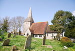
Alciston is a village and civil parish in the Wealden district of East Sussex, England. It is inland, just off the A27 road, about ten miles (16 km) north-west of Eastbourne and seven miles (11 km) east of Lewes. The ecclesiastical parish is linked with that of Selmeston and Berwick. Saxon in origin, its name was then Aelfsige; it is mentioned in the Domesday Book. The present 14th-century church, of unknown dedication, is built of chalk from the nearby South Downs. There is a large medieval tithe barn in the village. It is 170 feet (52 m) long and is the largest in Sussex. Every Good Friday, the road outside the Rose Cottage Inn is closed for the villagers to take part in a traditional skipping contest.The historian C.V. Wedgwood is buried in the church graveyard.
Excerpt from the Wikipedia article Alciston (License: CC BY-SA 3.0, Authors, Images).Alciston
The Village, Wealden Alciston
Geographical coordinates (GPS) Address Nearby Places Show on map
Geographical coordinates (GPS)
| Latitude | Longitude |
|---|---|
| N 50.83 ° | E 0.14 ° |
Address
The Village
BN26 6UT Wealden, Alciston
England, United Kingdom
Open on Google Maps


