place

St Mary the Virgin's Church, Wiggenhall

Church of England church buildings in NorfolkChurches preserved by the Churches Conservation TrustEnglish Gothic architecture in NorfolkEngvarB from September 2013G. E. Street buildings
Grade I listed churches in Norfolk
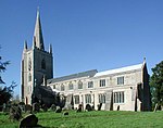
St Mary, Wiggenhall St Mary, Norfolk geograph.org.uk 477173

St Mary the Virgin's Church is a redundant Anglican church in the civil parish of Wiggenhall St Germans, Norfolk, England. It is recorded in the National Heritage List for England as a designated Grade I listed building, and is under the care of the Churches Conservation Trust. The church stands at the end of a lane to the north of the village of Wiggenhall St Mary the Virgin, some 5 miles (8 km) south of King's Lynn. It is notable particularly for the quality of carving of its wooden fittings.

Excerpt from the Wikipedia article St Mary the Virgin's Church, Wiggenhall (License: CC BY-SA 3.0, Authors, Images).

St Mary the Virgin's Church, Wiggenhall
Church Road, King's Lynn and West Norfolk Wiggenhall St. Germans

Geographical coordinates (GPS) Address Nearby Places
placeShow on map

Wikipedia: St Mary the Virgin's Church, WiggenhallContinue reading on Wikipedia

Geographical coordinates (GPS)

Latitude Longitude
N 52.7042 ° E 0.3409 °
placeShow on map

Address

Church Road
PE34 3EH King's Lynn and West Norfolk, Wiggenhall St. Germans
England, United Kingdom
mapOpen on Google Maps

St Mary, Wiggenhall St Mary, Norfolk geograph.org.uk 477173
Share experience

Nearby Places

Wiggenhall St Mary Magdalen

Wiggenhall St Mary Magdalen is a civil parish and village in the English county of Norfolk. It is 6 miles (9.7 km) south of the town of King's Lynn on the west bank of the River Great Ouse. It covers an area of 17.76 km2 (6.86 sq mi) and had a population of 729 in 304 households in the 2011 census. For the purposes of local government, it falls within the district of King's Lynn and West Norfolk. The villages name means 'Wicga's nook of land'.In the Domesday Book of 1085, it appears that all two of the Wiggenhall parishes were at that time a single parish named Wiggenhall, of modest size and sharing half a water mill on the old Wiggenhall Eau (the watercourse which ran through the parish before the Great Ouse arrived in the 13th Century) with Runcton Holme. The earliest evidence of settlement is therefore the parish church of St Mary Magdalen, which is situated in the very northeastern corner of the parish. Most of the early settlement appears to have occurred here, probably due to the presence of a levee along the western side of the River Great Ouse, made of silts deposited by a former watercourse, the Wiggenhall Eau. The church itself is largely Perpendicular in style, but the tower may date from as early as the 13th century, which is corroborated by the entry in the Register of Crabhouse Priory which tells of the Nuns taking refuge at the Church from a flood in the early 13thC. Today the church is almost entirely red brick, with a façade that is the result of a thoroughly 15th century rebuilding. The Parish contains two centres of population: around the Parish Church in the North, and to the South of Crabhouse Priory in the far South, now known as Stowbridge, which also extends into neighbouring parishes. John Howard, 1st Duke of Norfolk, KG, Earl Marshal (c.1425 – 22 August 1485) was the grandson of Sir John Howard of Wiggenhall. A tidal bore travels up the Great Ouse which is the area's most significant topographical feature. Magdalen Gate railway station was the name of the station on the Great Eastern Railway.