Kingston Deverill
Civil parishes in WiltshireEngvarB from August 2019OpenDomesdayVillages in Wiltshire

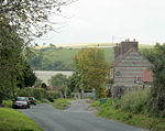
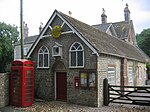
Kingston Deverill is a village and civil parish in Wiltshire, England. Its nearest towns are Mere, about 3+1⁄2 miles (6 km) to the southwest, and Warminster, about 5 miles (8 km) to the northeast. The parish and its demographic figures include the village of Monkton Deverill. To the north of the village, under the slope of Cold Kitchen Hill, is the hamlet of Whitepits. The parish is in the Deverill Valley which carries the upper waters of the River Wylye. The six villages of the valley – Kingston, Monkton, Brixton Deverill, Hill Deverill, Longbridge Deverill and Crockerton – are known as the Deverills.
Excerpt from the Wikipedia article Kingston Deverill (License: CC BY-SA 3.0, Authors, Images).Kingston Deverill
Geographical coordinates (GPS) Address Nearby Places Show on map
Geographical coordinates (GPS)
| Latitude | Longitude |
|---|---|
| N 51.133 ° | E -2.221 ° |
Address
BA12 7HE , Kingston Deverill
England, United Kingdom
Open on Google Maps


