Monkton Deverill
EngvarB from July 2016Former civil parishes in WiltshireIncomplete lists from February 2011Villages in Wiltshire

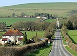
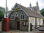
Monkton Deverill (anciently known as East Monkton) is a village and former civil parish in Wiltshire, England, about five miles south of Warminster and four miles northeast of Mere. It stands on the River Wylye and forms part of a group of villages known as the Upper Deverills.
Excerpt from the Wikipedia article Monkton Deverill (License: CC BY-SA 3.0, Authors, Images).Monkton Deverill
Hindon Road,
Geographical coordinates (GPS) Address Nearby Places Show on map
Geographical coordinates (GPS)
| Latitude | Longitude |
|---|---|
| N 51.135 ° | E -2.207 ° |
Address
Hindon Road
Hindon Road
BA12 7EZ , Kingston Deverill
England, United Kingdom
Open on Google Maps


