Van Cortlandt Park

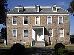
Van Cortlandt Park is a 1,146-acre (464 ha) park located in the borough of the Bronx in New York City. Owned by the New York City Department of Parks and Recreation, it is managed with assistance from the Van Cortlandt Park Alliance. The park, the city's third-largest, was named for the Van Cortlandt family, which was prominent in the area during the Dutch and English colonial periods. Van Cortlandt Park's sports facilities include golf courses and several miles of paths for running, as well as facilities for baseball, basketball, cricket, cross-country running, football, horseback riding, lacrosse, rugby, soccer, softball, swimming, tennis and track and field. The park also contains five major hiking trails and other walking trails. Its natural features include Tibbetts Brook; Van Cortlandt Lake, the largest freshwater lake in the Bronx; old-growth forests; and outcrops of Fordham gneiss and Inwood marble. Contained within the park is the Van Cortlandt House Museum, the oldest surviving building in the Bronx, and the Van Cortlandt Golf Course, the oldest public golf course in the country. The land that Van Cortlandt Park now occupies was purchased by Jacobus Van Cortlandt from John Barrett around 1691. His son Frederick built the Van Cortlandt House on the property, but died before its completion. Later, the land was used during the Revolutionary War when the Stockbridge militia was destroyed by the Queen's Rangers. In 1888, the family property was sold to the City of New York and made into a public parkland. The Van Cortlandt House, which would later be designated as a historic landmark, was converted into a public museum, and new paths were created across the property to make it more passable. In the 1930s, the Robert Moses-directed construction of the Henry Hudson Parkway and Mosholu Parkway fragmented Van Cortlandt Park into its six discontinuous pieces. The last remaining freshwater marsh in New York State, Tibbetts Brook, was dredged and landscaped to accommodate construction, causing large-scale ecological disruption within the park. The 1975 New York City fiscal crisis caused much of the park to fall into disrepair. Gradual improvements began taking place from the late 1980s on including the addition of new pathways, signage, and security. In 2014, the "Van Cortlandt Park Master Plan 2034" was published, providing a concrete blueprint of the park's proposed redevelopment in the following years.
Excerpt from the Wikipedia article Van Cortlandt Park (License: CC BY-SA 3.0, Authors, Images).Van Cortlandt Park
Old Croton Aqueduct Trail, New York The Bronx
Geographical coordinates (GPS) Address Nearby Places Show on map
Geographical coordinates (GPS)
| Latitude | Longitude |
|---|---|
| N 40.897777777778 ° | E -73.883888888889 ° |
Address
Old Croton Aqueduct Trail
Old Croton Aqueduct Trail
10705 New York, The Bronx
New York, United States
Open on Google Maps


