Thames Gateway
Borough of SwaleEngvarB from October 2013Geography of EssexGeography of KentGeography of the London Borough of Barking and Dagenham ... and 13 more
Geography of the London Borough of BexleyGeography of the London Borough of HaveringGeography of the London Borough of NewhamGeography of the London Borough of Tower HamletsGeography of the River ThamesGeography of the Royal Borough of GreenwichHousing in LondonLondon sub-regionsMedwayRedevelopment projects in LondonThames GatewayThurrockTown and country planning in England
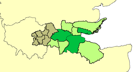
Thames Gateway is a term applied to an area around the Thames Estuary in the context of discourse around regeneration and further urbanisation. The term was first coined by the UK government and applies to an area of land stretching 70 kilometres (43 mi) east from inner east and south-east London on both sides of the River Thames and the Thames Estuary. It stretches from Westferry in Tower Hamlets to the Isle of Sheppey/Southend-on-Sea and extends across three ceremonial counties.
Excerpt from the Wikipedia article Thames Gateway (License: CC BY-SA 3.0, Authors, Images).Thames Gateway
Daniel Close, Thurrock
Geographical coordinates (GPS) Address Nearby Places Show on map
Geographical coordinates (GPS)
| Latitude | Longitude |
|---|---|
| N 51.487 ° | E 0.318 ° |
Address
Chafford Gorges Nature Reserve
Daniel Close
RM16 6PR Thurrock, Chafford Hundred
England, United Kingdom
Open on Google Maps


