place

Northleigh

Civil parishes in DevonDevon geography stubsEast Devon DistrictVillages in Devon
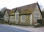
St Giles church, Northleigh (geograph 3231756)

Northleigh is a village and civil parish in the East Devon district of Devon, England. Its nearest town is Colyton, which lies approximately 3.5 miles (5.6 km) south-east from the village. The church of St Giles was built in the Perpendicular style and has a western tower. Features of interest are the plain Norman south doorway, two screens – one to the chancel and one to the north chancel chapel – and the Jacobean pulpit. It is a Grade II* listed building.

Excerpt from the Wikipedia article Northleigh (License: CC BY-SA 3.0, Authors, Images).

Northleigh
Backwells Mead, East Devon Northleigh

Geographical coordinates (GPS) Address Nearby Places
placeShow on map

Wikipedia: NorthleighContinue reading on Wikipedia

Geographical coordinates (GPS)

Latitude Longitude
N 50.758 ° E -3.142 °
placeShow on map

Address

Backwells Mead

Backwells Mead
EX24 6DE East Devon, Northleigh
England, United Kingdom
mapOpen on Google Maps

St Giles church, Northleigh (geograph 3231756)
Share experience

Nearby Places

Wilmington, Devon
Wilmington, Devon

Wilmington is a village between Axminster and Honiton in East Devon on the A35 road. The village is now in the parish of Widworthy although this is a recent change. Prior to 1989 houses on the north side of the A35 were in Offwell Parish and only those on the south side were in Widworthy. St Cuthbert's Church dates from the 14th century and nearby Castle Hill is of historical interest. From the 15th century onwards Wilmington sat astride the main Exeter to London road. It became the Honiton to Axminster Turnpike in 1765 but the importance of this route diminished when the Upottery to Ilminster turnpike opened in 1807, which led to a steady improvement in coaching facilities in the early 19th century on what is now the A30/A303 route over the Blackdown Hills from Honiton to Ilminster. In 1805 the village street rang to the clatter of horses' hooves as messengers raced through with news of the Battle of Trafalgar. In 2005 this historic event was marked by the unveiling of this plaque on the White Hart Inn. The plaque records details of the messengers and remembers local men who fought at the Battle. The Trafalgar Way climbs out of Honiton onto the ridge by way of Springfield Lane before descending into Wilmington along the A35. It passes through Wilmington village before leaving the A35 again and climbing steeply up Moorcox Lane to Moorcox Cross. From there it descends the next ridge to Shute Pillars and then passes through Shute Woods along the line of an old Roman Road into Kilmington.