Rushey Mead
Areas of Leicester

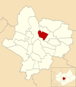
Rushey Mead is an area, suburb, electoral ward and administrative division of the city of Leicester, England. The population of the ward at the 2011 census was 15,962. It comprises the northern Leicester suburb of Rushey Mead in its entirety, as well as a part of the neighbouring area, suburb and electoral ward of Belgrave and historical parts of neighbouring Northfields and Thurmaston.
Excerpt from the Wikipedia article Rushey Mead (License: CC BY-SA 3.0, Authors, Images).Rushey Mead
Coatbridge Avenue, Leicester Rushey Mead
Geographical coordinates (GPS) Address Nearby Places Show on map
Geographical coordinates (GPS)
| Latitude | Longitude |
|---|---|
| N 52.66 ° | E -1.11 ° |
Address
Soar Valley College
Coatbridge Avenue
LE4 7ZS Leicester, Rushey Mead
England, United Kingdom
Open on Google Maps


