place

Marshchapel

Civil parishes in LincolnshireEast Lindsey DistrictUse British English from January 2014Villages in Lincolnshire
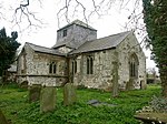
St Mary's church, Marsh Chapel geograph.org.uk 2997986

Marshchapel is a coastal village and civil parish in the East Lindsey district of Lincolnshire, England. It is approximately 11 miles (18 km) south-east from Grimsby and 13 miles (21 km) north-east from Louth. It includes the hamlets of West End and Eskham.Marshchapel has a village store cum post office, a primary school, and no public houses that are currently open, The church, dedicated to St Mary is a Grade I listed building dating from the 15th century with a chancel dating from 1848. St Mary's is often referred to as the "Cathedral of the Marshes". In the churchyard is a cross dating from the 14th century which was originally sited at the crossroads near West End. It is both Grade II listed and a scheduled monument.Marshchapel Primary School was originally built as a National School and was rebuilt in 1872, and has been known by its current name since September 1999.Marshchapel was the site of Anglo-Saxon salt-working.

Excerpt from the Wikipedia article Marshchapel (License: CC BY-SA 3.0, Authors, Images).

Marshchapel
Sea Dykeway, East Lindsey Marshchapel

Geographical coordinates (GPS) Address Nearby Places
placeShow on map

Wikipedia: MarshchapelContinue reading on Wikipedia

Geographical coordinates (GPS)

Latitude Longitude
N 53.473479 ° E 0.045934 °
placeShow on map

Address

Sea Dykeway

Sea Dykeway
DN36 5SX East Lindsey, Marshchapel
England, United Kingdom
mapOpen on Google Maps

St Mary's church, Marsh Chapel geograph.org.uk 2997986
Share experience

Nearby Places

Louth Navigation
Louth Navigation

The Louth Navigation was a canalisation of the River Lud. It ran for 11 miles (18 km) from Louth in Lincolnshire, England, to Tetney Haven, at the mouth of the Humber. It was authorised by act of Parliament in 1763 and completed in 1770, under the supervision of the engineer John Grundy Jr. and then by James Hoggard. Eight locks were required to overcome the difference in altitude, six of which were constructed with sides consisting of four bays. The act did not provide the normal provisions for raising capital for the construction, as finance could only be obtained by leasing of the tolls. When completed, the commissioners leased the tolls to Charles Chaplin, who held ten shares and was also a commissioner, for an initial period of seven years. When the lease was due for renewal, no other takers were found, and Chaplin was granted a 99-year lease, despite the fact that the act did not authorise such an action. He collected the tolls but failed to maintain the navigation. When complaints were received, a new act of Parliament was obtained in 1828 (9 Geo. 4. c. xxx), to alter the tolls and legalise Chaplin's long lease. The lease was transferred to two railway companies in 1847, and reverted to the commissioners in 1876. The operation was a moderate success until the beginning of the twentieth century, when there was a rapid decline in income, and the canal formally closed in 1924. Because the canal was also a land drainage channel, it was not subject to infilling, and is now a designated main river, managed by the Environment Agency that drains the surrounding land managed by the Lindsey Marsh Internal Drainage Board. It is as a feeder for Covenham Reservoir, from which treated water enters the public water supply. Water from Waithe Dike supplements the supply, effectively flowing upstream along the canal, and when required, additional water is pumped into the canal along a pipeline from the Great Eau.

Covenham Reservoir
Covenham Reservoir

Covenham Reservoir, located in East Lindsey is a 200-acre reservoir and treatment works constructed between 1963 and 1978 by W. & C. French. The reservoir was built next to the Louth Navigation canal and acts as a pumped storage reservoir from the canal, and can be supplemented by transfer schemes from Great Eau and Long Eau rivers.Opened in 1972 by Princess Alexandra, the reservoir was subject to some controversy as it was to be built on high grade agricultural land. The reservoir is approximately 1 km by 1 km in size and the depth is approximately 20m. Remedial works concerning a slip (movement) in the north embankment were undertaken at some point.The reservoir is situated between Grimsby and Louth in Lincolnshire. The reservoir hosts a watersports centre offering sailing, waterskiing and diving with a perimeter walkway open to the public. Built on the Lincolnshire coastal marsh, the sides of the reservoir offer views over surrounding farmland towards Grimsby, to the north, the coast, Louth and the Lincolnshire Wolds to the west. The reservoir acts as storage for times of low aquifer recharge in the area, and can be used to prevent saline intrusion into the Lincolnshire chalk aquifer which is the primary source of water in East Lincolnshire. The return of treated effluent from Louth to the Louth Canal, and Great Eau transfer scheme also help to maintain the water levels of the reservoir in this relatively dry region of the UK.The reservoir is constructed of walls all around, raised 20m above the low lying lincolnshire marsh. The structure is concrete lined, which prevents growth of marginal plants, however this does not prevent the reservoir attracting varied waterfowl and other birds. The reservoir primarily serves the water needs of the Grimsby and Cleethorpes conurbation, as well as being a supply feed for Louth, Mablethorpe and Skegness. In 2012 a £40 million pipeline linking the reservoir to the town of Boston in the south of the county began, and is expected to be capable of transferring 26 million litres of water a day.

Grainthorpe
Grainthorpe

Grainthorpe is a small village and civil parish in the East Lindsey district of Lincolnshire, England. It is situated 7 miles (11 km) north-east from the town of Louth, and approximately 3 miles (5 km) from the Lincolnshire coast. The civil parish includes the hamlets of Wragholme to the north-west, and Ludney to the south-east. The population of Conisholme is included in the 2011 census. Grainthorpe is listed in the 1086 Domesday Book as "Germundtorp", with 28 households. The deserted medieval village of Swinehope was believed to be cited here, abandoned when its harbour silted up. There was a medieval saltern at the hamlet of Wragholme.The parish church is a Grade I listed building dedicated to St Clement and dating from 1200, with later alterations, additions, and restorations. It has a 15th-century font. The churchyard contains war graves of a soldier and a Royal Flying Corps airman of the First World War.Grainthorpe Hall is an early 18th-century red-brick house, which is Grade II listed.Grainthorpe has its own primary school, village hall and post office, although the post office is currently open only two days a week in the Church Hall. The Coach house adjacent to the old Mill has been restored, and has re-opened as a village shop and tea room. There is also now a village shop Gilimans, selling supplies and pet food. Prior to this, the village's nearest shops were in the nearby villages of Marshchapel, North Somercotes, and Alvingham. Also sited in the village are playing fields which consist of a tennis court, football pitch and cricket pitch.