place

Basic City, Virginia

1890 establishments in Virginia1924 disestablishments in VirginiaFormer municipalities in VirginiaGeography of Augusta County, VirginiaPopulated places disestablished in 1924
Populated places established in 1890Waynesboro, Virginia
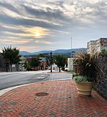
Downtown building in Basic City, Virginia

Basic City was an incorporated town located in Augusta County, Virginia, in the United States. Formed in 1890, it was named after a process for steel manufacture. This process was to be implemented in Basic City, and gave rise to land speculation. There was a boomtown rally of manufacturing and commercial development in Basic City between 1890 and 1893 as two railroads crossed here at a point called The Iron Cross: the Norfolk and Western and the Chesapeake and Ohio. Basic City was once bigger than the surrounding city of Waynesboro, Virginia. As the national economy experienced a depression between 1893 and 1896, sources of investment money disappeared and many new industries in Basic City experienced bankruptcy and closed. The town's real estate bubble burst and many businesses started between 1890 and 1893 did not survive. In 1924, Basic City consolidated with the adjacent Town of Waynesboro, which had been formed in 1798. The new name for the town was called Waynesboro-Basic. It was later renamed "Waynesboro". In 1948, the Town of Waynesboro became an independent city. However, Basic City had become one of the "Lost Towns" of Virginia. In modern times, only a handful of buildings and businesses bear the Basic name. One of them is the Basic City Luncheonette. The city-owned Basic Park is another. The Basic City Beer Company is a recent enterprise set up in the east end of the otherwise-vacant former Virginia Metalcrafters fabrication complex. At least one church, Basic United Methodist Church (BUMc) has long had the word Basic in its name.

Excerpt from the Wikipedia article Basic City, Virginia (License: CC BY-SA 3.0, Authors, Images).

Basic City, Virginia
North Delphine Avenue,

Geographical coordinates (GPS) Address Nearby Places
placeShow on map

Wikipedia: Basic City, VirginiaContinue reading on Wikipedia

Geographical coordinates (GPS)

Latitude Longitude
N 38.070833333333 ° E -78.874166666667 °
placeShow on map

Address

North Delphine Avenue

North Delphine Avenue
22998
Virginia, United States
mapOpen on Google Maps

Downtown building in Basic City, Virginia
Share experience

Nearby Places

Virginia Metalcrafters Historic District

The Virginia Metalcrafters Historic District encompasses a historic industrial complex at 1010 East Main Street in Waynesboro, Virginia. The complex includes one large multi-section brick factory, a number of small outbuildings (most in deteriorated condition), and the ruins of at least one collapsed building. The district is named for the Virginia Metalcrafters Company, which operated out of the complex from 1925 until 2006 and produced reproduction hardware for historic sites including Colonial Williamsburg, Mystic Seaport, and Old Salem.The building was added to the National Register of Historic Places in 2015.The complex was purchased in 2013 by VM Acquisitions and is being renovated as a Virginia Metalcrafters Marketplace with a focus on craftsmanship. Basic City Beer Co. was the first occupant to renovate and begin production of beer within the facility starting in 2016. They currently occupy a portion of the original foundry and the Showroom. The brewery is expanding to include a music venue called The Foundry opening in March of 2023 and a restaurant. Common Wealth Crush now occupies a portion of the main building. They work with local winemakers to produce small batch wines in their facility with plans for a tasting room to open in 2023. A local coffee roaster will occupy the building as well.Renovation work continues on the sawtooth portion of the building, and will provide space for additional tenants.

General Electric Specialty Control Plant

General Electric Specialty Control Plant is a 115 acres (47 ha) historic factory complex located in Waynesboro, Virginia. The complex includes three contributing buildings, one contributing site (the original formal entry drive), and two contributing structures. The historic buildings and structures are a 340,000-square-foot main plant building (1953–1955, 1960), the original water tower, water tank, a group of evolved and interconnected construction sheds built from 1953 to the present, and an airplane hangar (c. 1927). The property, a former airport, was acquired by General Electric in 1953. The Waynesboro plant was one of some 120 individual operating departments created as part of a decentralization effort by the General Electric Corporation. The Specialty Control Plant was responsible for the development of breakthrough technologies in areas ranging from America's military efforts to space travel to computer technology. The facility was sold to GENICOM on October 21, 1983.The property was originally on General Electric Drive. After the GENICOM sale, it was renamed GENICOM Drive. In 1994, GENICOM internally reorganized into two separate companies: Enterprising Solutions Services Company (ESSC) and Document Solutions Company (GENICOM). The road north of Hopeman Parkway was renamed Solutions Way while the southern part remained GENICOM Drive at the request of property owners in that area. In 2000, GENICOM entered bankruptcy and the building was sold to the newly formed Solutions Way Management. The substantially downsized GENICOM operated as a tenant through its 2003 merger that formed TallyGenicom until a further bankruptcy and dissolution in 2009. The building was added to the National Register of Historic Places in 2012.Solutions Way Management rents much of the facility to companies for light manufacturing, warehousing and distribution.