place

Blackboy Hill, Western Australia

Greenmount, Western AustraliaHistory of Western AustraliaMilitary camps in AustraliaMilitary installations in Western AustraliaState Register of Heritage Places in the Shire of Mundaring
Use Australian English from March 2014World War I memorials in AustraliaWorld War I sites in Australia
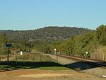
Blackboy Hill Greenmount from east 2004

Blackboy Hill was named after the Australian native "black boy" plants, Xanthorrhoea preissii, which dominated the site which is now absorbed into Greenmount, Western Australia. Originally a military camp, the facilities and adjacent structures were on the hill that is now used by St Anthony's Primary School and Church, and Greenmount Primary School. The remaining land (which has been left as a memorial to the troops who used the training camp) is known on official documents and maps as the Blackboy Hill Commemorative Site, but local signage tends to refer to the location simply as Blackboy Hill.

Excerpt from the Wikipedia article Blackboy Hill, Western Australia (License: CC BY-SA 3.0, Authors, Images).

Blackboy Hill, Western Australia
Innamincka Road, Shire Of Mundaring

Geographical coordinates (GPS) Address Nearby Places
placeShow on map

Wikipedia: Blackboy Hill, Western AustraliaContinue reading on Wikipedia

Geographical coordinates (GPS)

Latitude Longitude
N -31.897 ° E 116.0456 °
placeShow on map

Address

Blackboy Hill War Memorial

Innamincka Road
6070 Shire Of Mundaring, Greenmount
Western Australia, Australia
mapOpen on Google Maps

Blackboy Hill Greenmount from east 2004
Share experience

Nearby Places

Darling Range Hotel
Darling Range Hotel

Darling Range Hotel was a hotel in Bellevue, Western Australia, on the end of the slope on the Great Eastern Highway at the 'bottom of' Greenmount Hill and just north of the former Bellevue railway station, and over the road from the Helena Vale Racecourse. The locality known earlier as 'Helena Vale' and 'East Midland', was near the border of the council in the hills above 'Greenmount Road Board' - (now Shire of Mundaring), and the 'Midland Junction Council' (now City of Swan). In the First World War, it was the nearest hotel to the Blackboy Hill army campIt was started as the East Midland Hotel, on the earlier name for the highway - the York Road. Despite the name the local councils called it 'The Bellevue Hotel'.The hotel was licensed in 1905, and its outward appearance changed over the years with change of owners and managers and circumstances.The owners, Licensees or Managers to the end of the First World War included:- Thomas Wilkins 1903-1913 W.K. Lamzed 1914-1916 H. Finlayson 1916-1920The longest connection on record was that of J.K. Robinson and S. Boyd 1950 -1960It was considered an excellent location and opportunity for owners and trainers with horses at the Helena Vale Racecourse.It was the base of a lengthy association with billiards and darts for the area.More historic hotels in the Midland - Bellevue area have been lost due to fire, loss of licence and neglect. The Darling Range Hotel building is one of the few remaining buildings in the area with well documented connections to the troops leaving Blackboy Hill Training Camp, and leaving Helena Vale Racecourse by railway to serve in the First World War. The building remained, with a different configuration from the first world war era, and was in potential threat of immanent demolishing to make way for a service station development, in an area that already has a significant concentration of service stations.

Greenmount National Park

Greenmount National Park is a national park in the locality of Greenmount, Western Australia, 22 km east of Perth. It is one of the smaller national parks along the Darling Scarp and is a component of the Darling Range Regional Park. Due to its proximity to John Forrest National Park, which used to be known as Greenmount National Park until 1928, and relationship to subsequent reserves to the south it is a vital scarp wildlife corridor. Bus tours were available from Perth in 1933 with Hill's Bus Tours offering passengers a tour around the park on Sundays in September. Beam Transport Ltd. offered a similar service through the Park to Mundaring Weir in 1937.As a feature adjacent to the Helena River Valley it has significance in Aboriginal folklore, and also featured very early on in early European settler's diaries. Mountain Quarry is one of several blue stone quarries located within the park, popular with rock climbers and walkers. Vehicle access to the quarry site is restricted; however a car-park and picnic facilities including toilets are within walking distance of the main site, which is completely accessible on foot. There are several panels containing historical information about the site spread around as part of the popular Railway Reserves Heritage Trail, which runs close to the quarry. The Boya/Koongamia leg of the Railway Reserves Heritage Trail, also known as the "Bridle Trail", curves around the south-western edge of the park, crossing through the Mountain Quarry car-park and picnic area. In the early 2000s significant bushfire damage occurred on the southern slopes of this park. Large fire-breaks bisect the park, serving as popular walking routes among locals. The western and northern slopes, visible from Great Eastern Highway, have extensive Watsonia infestations. In late 2005, the government authority in charge of the national park was taking steps to prevent vehicular access along the top of the ridge to the lookout due to vandalism and issues with residents adjacent to the park.The park is situated along the side of Greenmount Hill and has views over the Swan Coastal Plain below and Perth to the west. The dominant vegetation in the park is eucalypts such as marri and wandoo along with an array of wild flowers and heathland along the northern slopes. The hill is steep and contain several breakaways and rocky outcrops.