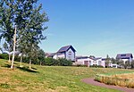
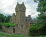
Fintry is a housing scheme in Dundee, Scotland. Fintry is located in the north of the city with Mill o' Mains to the west and Whitfield to the east. On the north, Fintry is bordered by farmland, including the Powrie Farm and Powrie Castle (from which one of the pubs in the area derives its name). Local parks include Powrie Park (at the north of the scheme) and Finlathen Park (in a deep valley to the south of the scheme, through which runs the Dighty Burn). Fintry had a population of 6592 in 2011.Customarily, the borders of the scheme are accepted as being: Forfar Road on the west side with Mill O'Mains, Longhaugh Road on the east side with Whitfield and the Dighty Burn on the southern side (inside Finlathen Park). On three of the four sides, and (formerly) half of the north side (see section on Cheviot Crescent and Grampian Gardens), Fintry's borders are defined by three to four storey high tenement blocks.
Fintry is in the North East ward of Dundee City Council, represented since May 2012 by Councillors Steven Rome and Willie Sawers of the Scottish National Party, and Councillor Gregor Murray, who is an Independent.
Fintry has two bars, the Powrie Bar at Cheviot Crescent and the Dolphin on Fintry Road. Fintry also has two chip shops, two Chinese takeaways known as the Blue Lagoon and Friendlies, and three Indian takeaways, often referred to as the Tartan Tandoori, Mazaydar and the Red Chilli. There are two churches, Fintry Parish Church of scotland and Our Lady of Sorrows Roman Catholic Church. The 22nd Dundee Scouts operates from a hall in the grounds of Fintry Parish Church, and there is also a Girls' Brigade company in the church itself. Mains of Fintry Pipe Band was formed in Fintry in 1972, by Pipe Major William Smith.
Other facilities in the community include the Finmill Community Centre on Findcastle Street, and the Library also on Findcastle Street. Fintry is served by three Primary Schools: Fintry Primary (non-denominational, on Findcastle Terrace) and Longhaugh Primary (non-denominational) and St Francis (Catholic school), the latter two both part of the North East campus, opened in 2018, on Lothian Crescent. Fintry is in the catchment area for Braeview Academy Secondary School (non-denominational) and St. Paul's R.C. Academy (Catholic school). There is a Nursery School on the same site as Fintry Primary, and Quarry View nursery is part of the new North East campus on Lothian Crescent. The new Fintry Primary school was completed in around 2010, funded as a Public–private partnership, replacing a "temporary" building originally erected in the 1950s.


